Geolocalizar

Mapa topográfico Wolverhampton

Haga clic en el mapa para ver la altitud.

Acerca de este mapa

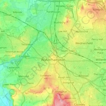
Nombre: Mapa topográfico Wolverhampton, altitud, relieve.

Lugar: Wolverhampton, West Midlands, England, United Kingdom (52.54391 -2.20688 52.63789 -2.04803)

Altitud media: 138 m

Altitud mínima: 80 m

Altitud máxima: 236 m

Otros mapas topográficos

Haga clic en un mapa para ver su topografía, su altitud y su relieve.

London

United Kingdom > England > London

Altitud media: 42 m

Croydon

United Kingdom > England > Greater London

Several apartment developments, for instance Altitude 25 (completed 2010), have been built in recent years, and several more are being built or planned. The construction of Saffron Square, which includes a 43-storey tower, began on Wellesley Road in 2011 and was completed in 2016. Other developments with…

Altitud media: 70 m

Putney

United Kingdom > England

Putney Heath is around 400 acres (160 hectares) less the nascent A3 road in size and rises to 45 metres (148 ft) above sea level. Because of its elevation, from 1796 to 1816 Putney Heath hosted a station in the shutter telegraph chain, which connected the Admiralty in London to its naval ships in Portsmouth.…

Altitud media: 18 m

Crewe

United Kingdom > England > Crewe

Altitud media: 53 m

Derby

United Kingdom > England > Derbyshire

Altitud media: 97 m

City of London

United Kingdom > England > City of London > City of London

The elevation of the City ranges from sea level at the Thames to 21.6 metres (71 ft) at the junction of High Holborn and Chancery Lane. Two small but notable hills are within the historic core, Ludgate Hill to the west and Cornhill to the east. Between them ran the Walbrook, one of the many "lost" rivers or…

Altitud media: 42 m

Plymouth

United Kingdom > England > Devon > Plymouth

The River Plym, which flows off Dartmoor to the north-east, forms a smaller estuary to the east of the city called Cattewater. Plymouth Sound is protected from the sea by the Plymouth Breakwater, in use since 1814. In the Sound is Drake's Island which is seen from Plymouth Hoe, a flat public area on top of…

Altitud media: 81 m

Woolacombe

United Kingdom > England > Devon > North Devon

Altitud media: 81 m

Sidmouth

United Kingdom > England > Sidmouth

Altitud media: 54 m

York

United Kingdom > England > York

Altitud media: 21 m

Leeds

United Kingdom > England

Lying in the eastern foothills of the Pennines, there is a significant variation in elevation within the city's built-up area. The district ranges from 1,115 feet (340 m) in the far west on the slopes of Ilkley Moor to about 33 feet (10 m) where the rivers Aire and Wharfe cross the eastern boundary. Land rises…

Altitud media: 94 m

Littleborough

United Kingdom > England

In the late 18th century, the low-altitude Summit Gap between Littleborough and Walsden was approved as the best route over the Pennines for the Rochdale Canal and the Manchester to Leeds railway; Hollingworth Lake was built at Littleborough's south side as a feeder reservoir to regulate the waters of the…

Altitud media: 266 m

Temple

United Kingdom > England > Cornwall

Altitud media: 246 m

Ealing

United Kingdom > England > Greater London

Altitud media: 26 m

Leigh

United Kingdom > England

Altitud media: 34 m

Salisbury

United Kingdom > England > Salisbury

Bishop of Salisbury Hubert Walter was instrumental in the negotiations with Saladin during the Third Crusade, but he spent little time in his diocese prior to his elevation to archbishop of Canterbury. The brothers Herbert and Richard Poore succeeded him and began planning the relocation of the cathedral into…

Altitud media: 96 m

Cambridge

United Kingdom > England > Cambridge

The city, like most of the UK, has a maritime climate highly influenced by the Gulf Stream. Located in the driest region of Britain, Cambridge's rainfall averages around 570 mm (22.44 in) per year, around half the national average, with some years occasionally falling into the semi-arid (under 500 mm (19.69…

Altitud media: 18 m

Eccles Pike

United Kingdom > England > Derbyshire > High Peak > Chapel-en-le-Frith > Whitehough > Whitehough Head

At the top of the hill is a commemorative plaque known as a topograph, showing a 360° relief of the surrounding landscape, placed by the community to mark the millennium. In early November 2011, the topograph was stolen. On 7 May 2013, it was replaced with one made from less valuable metal to discourage…

Altitud media: 233 m

Hengistbury Head

United Kingdom > England > Bournemouth, Christchurch and Poole > Bournemouth

In 1910 the first international aviation meeting ever held in Britain took place on a specially laid out aerodrome consisting of a mile of grassland between the "Double Dykes" and the nearby village of Tuckton. About twenty pioneer aviators from around the world participated in various competitions including…

Altitud media: 0 m

Banbury

United Kingdom > England > Cherwell > Banbury

Altitud media: 119 m

Portsmouth

United Kingdom > England > Hampshire > Portsmouth

By road, Portsmouth lies 73.5 miles (118.3 km) from Central London, 49.5 miles (79.7 km) west of Brighton, and 22.3 miles (35.9 km) east of Southampton. Portsmouth is situated primarily on Portsea Island and is the United Kingdom's only island city, although parts of it have expanded onto the mainland. Gosport…

Altitud media: 28 m

Carlisle

United Kingdom > England > Cumberland

Altitud media: 31 m

Richmond

United Kingdom > England > London

The town centre lies just below 33 ft (10m) above sea level. South of the town centre, rising from Richmond Bridge to an elevation of 165 ft (50m), is Richmond Hill. Just beyond the summit of Richmond Hill is Richmond Park, an area of 2,360 acres (9.55 km2; 3.7 sq mi) of wild heath and woodland originally…

Altitud media: 17 m

Durham

United Kingdom > England > County Durham

Altitud media: 119 m

Stroud

United Kingdom > England > Gloucestershire > Stroud

Altitud media: 135 m

High Willhays

United Kingdom > England > Devon > West Devon

High Willhays and Yes Tor are the only summits in England south of Kinder Scout in the Peak District to rise above 2,000 feet (610 m), apart from Black Mountain on the Welsh border. Before Ordnance Survey measured accurately the heights of High Willhays and Yes Tor many people believed Yes Tor was the higher…

Altitud media: 512 m

Rawmarsh

United Kingdom > England

Altitud media: 64 m

Stanley Park

United Kingdom > England > Liverpool

Altitud media: 43 m

Oxford

United Kingdom > England > Oxfordshire > Oxford

Altitud media: 81 m

Exeter

United Kingdom > England > Devon > Exeter

The city of Exeter was established on the eastern bank of the River Exe on a ridge of land backed by a steep hill. It is at this point that the Exe, having just been joined by the River Creedy, opens onto a wide flood plain and estuary which results in quite common flooding. Historically this was the lowest…

Altitud media: 99 m

Cheshunt

United Kingdom > England > Hertfordshire

Altitud media: 43 m

Stoke

United Kingdom > England > Stoke-on-Trent

Altitud media: 142 m

Darlington

United Kingdom > England > Darlington

Altitud media: 52 m

Emley Moor

United Kingdom > England > Kirklees

Altitud media: 210 m

Dunkery Beacon

United Kingdom > England > Somerset

Altitud media: 393 m

Ashdown Forest

United Kingdom > England > East Sussex > Wealden

Ashdown Forest is an ancient area of open heathland occupying the highest sandy ridge-top of the High Weald Area of Outstanding Natural Beauty. It is situated 30 miles (48 km) south of London in the county East Sussex, England. Rising to an elevation of 732 feet (223 m) above sea level, its heights provide…

Altitud media: 117 m

Royton

United Kingdom > England

Described in Samuel Lewis's A Topographical Dictionary of England (1848) as being in "aspect rather wild", Royton lies in a shallow valley amongst undulating land. The sources of the rivers Irk and Beal are to the northeast and east respectively. The Irk meanders southwesterly into Chadderton, and then onwards…

Altitud media: 181 m

Dronfield

United Kingdom > England > Dronfield

Altitud media: 159 m

Prestwich

United Kingdom > England

Altitud media: 76 m

Biggin Hill

United Kingdom > England > London

Altitud media: 171 m

Retford

United Kingdom > England > Nottinghamshire > Bassetlaw

In 1831, the Gas Works was built by James Malam and gaslights were lit in the town for the first time on 22 December 1831. The Square was lit by a cast iron light bearing five gas lamps at that time. The Gas Works became a target on 2 September 1916 when a German Zeppelin dropped 14 bombs on Retford. The…

Altitud media: 31 m

Sherborne

United Kingdom > England > Sherborne

Altitud media: 91 m

Basingstoke

United Kingdom > England > Hampshire > Basingstoke and Deane

Situated in a valley through the Hampshire Downs at an average elevation of 88 metres (289 ft) Basingstoke is a major interchange between Reading, Newbury, Andover, Winchester, and Alton, and lies on the natural trade route between the southwest of England and London. The area had been something of an…

Altitud media: 109 m

Frome

United Kingdom > England > Somerset

Altitud media: 97 m

Redhill

United Kingdom > England > Surrey > Reigate and Banstead

To the north, the town joins with the village of Merstham, north of which there is a "wind gap" in the chalk hills of the North Downs, at an elevation of 120 metres (390 ft) above sea level, through which the A23 road heads in from London. Geologists have speculated that there may once have been a…

Altitud media: 107 m

St Albans

United Kingdom > England > Hertfordshire > St Albans

St Albans was an ancient borough created following the dissolution of the monastery in 1539. It consisted of the ancient parish of St Albans (also known as the Abbey parish) and parts of St Michael and St Peter. The municipal corporation was reformed by the Municipal Corporations Act 1835 and the boundary was…

Altitud media: 100 m

Swindon

United Kingdom > England > Swindon

Swindon has an oceanic climate (Cfb in the Köppen climate classification), like the vast majority of the British Isles, with cool winters and warm summers. The nearest official weather station is RAF Lyneham, about 10 miles (16 km) west southwest of Swindon town centre. The weather station's elevation is 145…

Altitud media: 108 m

Heswall

United Kingdom > England

Altitud media: 36 m

Moreton

United Kingdom > England

Altitud media: 16 m

Poole Bay

United Kingdom > England

Altitud media: 0 m

Bideford Bay

United Kingdom > England

Altitud media: 0 m

Mount's Bay

United Kingdom > England

Altitud media: 0 m

Falmouth Bay

United Kingdom > England

Altitud media: 0 m

Lyme Bay

United Kingdom > England

Altitud media: 0 m

Liverpool Bay

United Kingdom > England

Altitud media: 0 m

Gayton

United Kingdom > England

Altitud media: 41 m

Keston

United Kingdom > England

Altitud media: 104 m

Harefield

United Kingdom > England

Altitud media: 66 m

Eastham Village

United Kingdom > England

Altitud media: 24 m

Greasby

United Kingdom > England

Altitud media: 32 m

Middleton

United Kingdom > England

Altitud media: 113 m

Atherton

United Kingdom > England

There were several ministers of note of Chowbent Chapel including James Wood, the "General" (1672–1759), who distinguished himself at the Battle of Preston in 1715. Thomas Walker Horsfield (1792–1837) was a historian and topographer. Joseph Nightingale (1775–1824), born in Chowbent, was a prolific…

Altitud media: 69 m

Tottenham

United Kingdom > England

Tottenham's elevation is approximately 33 ft (10 m) above sea level.

Altitud media: 25 m

Old Town

United Kingdom > England

Altitud media: 7 m

Raby Mere

United Kingdom > England

Altitud media: 33 m

Acton

United Kingdom > England

Altitud media: 23 m

Noak Hill

United Kingdom > England

Altitud media: 67 m

Shining Tor

United Kingdom > England > Cheshire East

Shining Tor is the highest hill in Cheshire, England. The summit has an elevation of 559 m (1,834 ft) above sea level. It is in the Peak District, between the towns of Macclesfield in Cheshire and Buxton in Derbyshire, and is on the administrative boundary between Derbyshire and Cheshire East. The hill is at…

Altitud media: 440 m

Milnrow

United Kingdom > England

Altitud media: 210 m

Bebington

United Kingdom > England

Bebington is on the eastern side of the Wirral Peninsula, approximately 10 km (6.2 mi) south-south-east of the Irish Sea at New Brighton, about 7.5 km (4.7 mi) east-north-east of the Dee Estuary at Gayton and less than 2 km (1.2 mi) west-north-west of the River Mersey at New Ferry. The area is situated at an…

Altitud media: 28 m

Lunt

United Kingdom > England

Altitud media: 11 m

Wombwell

United Kingdom > England

Altitud media: 69 m

Golborne

United Kingdom > England

Altitud media: 38 m

Hugh Town

United Kingdom > England

Altitud media: 2 m

Southall

United Kingdom > England

Altitud media: 30 m

Thingwall

United Kingdom > England

Altitud media: 55 m

Botany Bay

United Kingdom > England

Altitud media: 70 m