
Mapa topográfico Bedford
Haga clic en el mapa para ver la altitud.
Bedford
As with the rest of the United Kingdom, Bedford has a maritime climate, with a limited range of temperatures, and generally even rainfall throughout the year. The nearest Met Office weather station to Bedford is Bedford (Thurleigh) airport, about 6.5 miles (10.5 km) north of Bedford town centre at an elevation of 85 metres (279 ft). Temperature extremes at the site have ranged from 39.5 °C (103.1 °F) in July 2022, down to −15.3 °C (4.5 °F) in January 1982. However, such extremes would likely be superseded if longer-term records were available – Historically, the nearest weather station to Bedford was Cardington about 2.4 miles (3.9 km) south south east of the town centre with an elevation of 30 metres (98 ft). This location recorded a minimum of −18.3 °C (−0.9 °F) during January 1963.
Acerca de este mapa
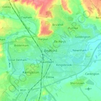
Nombre: Mapa topográfico Bedford, altitud, relieve.
Lugar: Bedford, England, MK40 1SU, United Kingdom (52.09638 -0.50750 52.17638 -0.42750)
Altitud media: 37 m
Altitud mínima: 20 m
Altitud máxima: 83 m
Otros mapas topográficos
Haga clic en un mapa para ver su topografía, su altitud y su relieve.
Wymington
United Kingdom > England > Bedford
During the Second World War, families in and near Wymington took in children evacuated from urban areas in response to bombing raids, as was typical of many rural towns and villages. In August, 1944 a damaged United States Army Air Forces B-17 "Miss Liberty Belle" based at nearby RAF Chelveston crashed in the…
Altitud media: 86 m