
Haz una donación
Mapa topográfico Mandaluyong
Haga clic en el mapa para ver la altitud.
Haz una donación
Mandaluyong
Another claims that the Spaniards named the place based on the report of a navigator named Acapulco, who saw the rolling hills frequently being lashed at by daluyong (“big waves from the sea”). This seems to confirm traditional pre-Hispanic stories that giant waves from the sea would meet the adjoining hills of the vast lowland, referred to as salpukan ng alon. Felix dela Huerta, a Franciscan historian, observed that the rolling topography of this land resembled giant waves of the sea.
Haz una donación
Acerca de este mapa
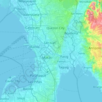
Nombre: Mapa topográfico Mandaluyong, altitud, relieve.
Lugar: Mandaluyong, Metro Manila, 1551, Philippines (14.41744 120.87390 14.73744 121.19390)
Altitud media: 33 m
Altitud mínima: -3 m
Altitud máxima: 454 m
Haz una donación
Otros mapas topográficos
Haga clic en un mapa para ver su topografía, su altitud y su relieve.
Palawan
Palawan's almost 2,000 kilometers (1,200 mi) of irregular coastline is lined with rocky coves and sugar-white sandy beaches. It also harbors a vast stretch of virgin forests that carpet its chain of mountain ranges. The mountain heights average 1,100 meters (3,500 ft) in altitude, with the highest peak rising…
Altitud media: 35 m
Angeles
Sapangbato is the largest barangay in Angeles in terms of territory, with a total land area of 104,694 sq. meters and a population of 11,262. Located northwest of Angeles near Clark Freeport Zone, it is identified as the barangay in Angeles with the highest elevation of 750 feet above sea level. It is home to…
Altitud media: 98 m
Haz una donación
Haz una donación
Mindanao
In the eastern portion of the island, from Bilas Point in Surigao del Norte to Cape San Agustin in Davao Oriental, is a range of complex mountains known in their northern portion as the Diwata Mountains. This range is low and rolling in its central portion. A proposed road connecting Bislig on the east coast…
Altitud media: 54 m
Batangas
Batangas' landscape is largely of plains dotted by mountains, including one of the world's smallest volcanoes, Mt. Taal, with an elevation of 600 metres (2,000 ft), located in the middle of the Taal Lake. Other important peaks are Mount Macolod with an elevation of 830 metres (2,720 ft), Mt. Banoy with 960…
Altitud media: 126 m
Haz una donación
Laguna de Bay
Laguna de Bay (Spanish for "Lagoon/Lake of Bay"; Tagalog: Lawa ng Bay, [baɪ]), also known as Laguna Lake, is the largest lake in the Philippines. It is located southeast of Metro Manila, between the provinces of Laguna to the south and Rizal to the north. A freshwater lake, it has a surface area of 911–949…
Altitud media: 62 m
Haz una donación
Haz una donación
Haz una donación
Haz una donación
Haz una donación
Haz una donación
Chico River
The Chico River, has a total length of 233 kilometres (145 mi), making it the longest tributary of the Cagayan River, itself the largest river in the Philippines. For centuries it has been central to farming, trading, livelihoods, and daily life, whether as a benefit or hindrance. It provided a source of water…
Altitud media: 585 m
Haz una donación
Haz una donación
Tagum
One of the significant accomplishments of the officialdom of Tagum during the 1990s was its elevation from a second to the first-class municipality. This opened a gateway to increase its financial resources through the Internal Revenue Allocation (IRA) from the national government and local revenues. This was…
Altitud media: 91 m
Haz una donación
Siniloan
Buruwisan falls is located in Siniloan Laguna which is around eighty kilometers east of Manila. To get there we had to cross the long winding roads of Teresa and Bugarin to Mabitac. By public transport Take UV express vans bound to Tanay market in Starmall-Shaw terminal (P70). Then in Tanay market, ride a…
Altitud media: 120 m
Haz una donación
Haz una donación
Quezon
Despite its being a first-class municipality, Quezon took some time to move forward with its development goals on account of the precarious peace situation in the area. Due in part to its mountainous topography, Quezon had been an ideal hotbed of communist movements that infiltrated the local government since…
Altitud media: 487 m
Haz una donación
Pulilan
The municipality is generally of flat topography. Eleven (11) of its barangays are bounded by the Angat River. The rest are flat irrigated rice lands. Soil types vary from sandy loam to clay loam which makes the municipality suitable to a wide range of agricultural products.
Altitud media: 10 m
Davao del Sur
The province enjoys a mild, pleasant climate all year round. Because of its topographical characteristics and geographical location, it is rarely visited by typhoons. There is no pronounced wet or dry season. The coolest months are from November to February with an average temperature of 25 °C (77 °F).…
Altitud media: 278 m
Haz una donación
Haz una donación
Greenhills
Greenhills and the adjacent West Crame are the only barangays in San Juan that are not entirely situated on tuff and tuffaceous sedimentary rock, with parts of the barangay being situated on top of pyroclastic flow adobe deposits. The highest elevation of San Juan can be found in Greenhills at its border with…
Altitud media: 32 m
Haz una donación
Caraga
Father Saturnino Urios University, was founded by Caraga's most loved Spanish missionary, Fr. Saturnino Urios S.J. in 1990. The Commission on Higher Education (CHED) recognized Father Saturnino Urios University as one of the best schools in the region producing top notchers in national board examinations in…
Altitud media: 136 m
Haz una donación
Haz una donación
Dumaguete
As a coastal city, it is bounded on the east by the Bohol Sea and the Tañon Strait, serving as a natural border of southeastern Negros Island Region to the neighboring Central Visayas. The city's topography is generally flat from two to six kilometers from the shoreline. It slopes gently upwards to the…
Altitud media: 55 m
Bacolod
Bacólod (English: Bacolod), is derived from bakólod (Old Spelling: bacólod), the Old Hiligaynon (Old Ilonggo) (Old Spelling: Ylongo and Ilongo) word for a "hill, turtle, mound, rise, hillock, down, any small eminence or elevation", since the resettlement was founded on a stony, hilly area, now the barangay…
Altitud media: 54 m
Calapan
Philippines > Oriental Mindoro
The overall land characteristic is a wide plain with rivers, interspersed with wetlands at the seacoast periphery. The highest elevation is 187 m (614 ft) above sea level at Bulusan Hill, a 6-kilometre (3.7 mi) long landform east of the city, which interrupts the mostly flat terrain north-east of the…
Altitud media: 12 m
Haz una donación
Aklan
Mount Nausang, is the previous highest peak in Aklan, standing at 5,138 ft (1,566 m), but Madi-ac Peak is higher, with an elevation of 1,716 m (5,630 ft) above sea level, Madi-ac it is not an independent mountain, it is still part of Mount Madja-as sub-summit with only Topographic prominence peak of 30 m (98…
Altitud media: 94 m
Haz una donación
Haz una donación
Haz una donación
Obando
Flat and low-lying coastal plains characterize the general topography of Obando. The area was formerly an estuary, but it filled up partially from the peripheral parts of each sand bar and sand spit and formed up into current figure that mainly consisted of commercial district, partly industrial district,…
Altitud media: 4 m
Haz una donación