
Gracias por apoyar a este sitio ❤️
Haz una donación
Haz una donación
Mapa topográfico Calapan
Haga clic en el mapa para ver la altitud.
Gracias por apoyar a este sitio ❤️
Haz una donación
Haz una donación
Calapan
The overall land characteristic is a wide plain with rivers, interspersed with wetlands at the seacoast periphery. The highest elevation is 187 m (614 ft) above sea level at Bulusan Hill, a 6-kilometre (3.7 mi) long landform east of the city, which interrupts the mostly flat terrain north-east of the Halcon-Baco Mountain Range.
Gracias por apoyar a este sitio ❤️
Haz una donación
Haz una donación
Acerca de este mapa
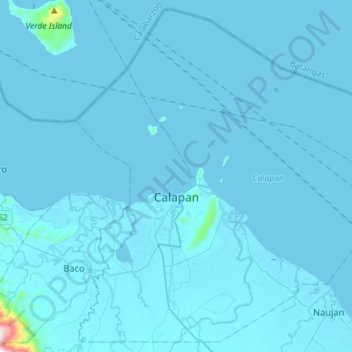
Nombre: Mapa topográfico Calapan, altitud, relieve.
Lugar: Calapan, Oriental Mindoro, Mimaropa, 5200, Philippines (13.29974 121.09781 13.56273 121.38291)
Altitud media: 12 m
Altitud mínima: -2 m
Altitud máxima: 843 m
Gracias por apoyar a este sitio ❤️
Haz una donación
Haz una donación
Otros mapas topográficos
Haga clic en un mapa para ver su topografía, su altitud y su relieve.