
Mapa topográfico Cotopaxi
Mapa interactivo
Haga clic en el mapa para ver la altitud.
Acerca de este mapa
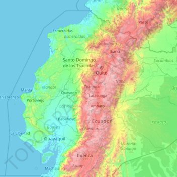
Nombre: Mapa topográfico Cotopaxi, altitud, relieve.
Lugar: Cotopaxi, Ecuador (-3.38685 -81.45378 1.73315 -76.33378)
Altitud media: 828 m
Altitud mínima: -2 m
Altitud máxima: 6.125 m
Otros mapas topográficos
Haga clic en un mapa para ver su topografía, su altitud y su relieve.
Isinche Grande
Ecuador > Cotopaxi > Pujilí > Pujilí
Isinche Grande, Pujilí, Cotopaxi, 050404, Ecuador
Altitud media: 3.096 m
Macaló Chico
Ecuador > Cotopaxi > Latacunga > Mulaló
Macaló Chico, Mulaló, Latacunga, Cotopaxi, Ecuador
Altitud media: 3.094 m
Mulliquindil
Mulliquindil, Salcedo, Cotopaxi, Ecuador
Altitud media: 2.876 m
Río Esmeraldas
Ecuador > Cotopaxi > La Maná > Pucayacu
Río Esmeraldas, Pucayacu, La Maná, Cotopaxi, Ecuador
Altitud media: 1.021 m
Jalligua
Ecuador > Cotopaxi > Pangua > Moraspungo
Jalligua, Moraspungo, Pangua, Cotopaxi, Ecuador
Altitud media: 452 m
La Victoria
La Victoria, Pujilí, Cotopaxi, 050455, Ecuador
Altitud media: 3.100 m
Tingo La Esperanza
Ecuador > Cotopaxi > Pujilí > Tingo
Tingo La Esperanza, Tingo, Pujilí, Cotopaxi, Ecuador
Altitud media: 1.754 m
San Miguel
Ecuador > Cotopaxi > Latacunga > Belisario Quevedo
San Miguel, Belisario Quevedo, Latacunga, Cotopaxi, 050106, Ecuador
Altitud media: 2.759 m
El Banco de San Isisdro
Ecuador > Cotopaxi > Latacunga > Alaques
El Banco de San Isisdro, Alaques, Latacunga, Cotopaxi, Ecuador
Altitud media: 3.069 m
Palo Seco
Ecuador > Cotopaxi > Pangua > Moraspungo
Palo Seco, Moraspungo, Pangua, Cotopaxi, Ecuador
Altitud media: 687 m
Pastocalle
Ecuador > Cotopaxi > Latacunga > Latacunga
Pastocalle, Latacunga, Cotopaxi, 050108, Ecuador
Altitud media: 2.851 m
Ramón Campaña
Ramón Campaña, Pangua, Cotopaxi, Ecuador
Altitud media: 1.688 m
Cuturivi Chico
Ecuador > Cotopaxi > Pujilí > Pujilí
Cuturivi Chico, Pujilí, Cotopaxi, 050404, Ecuador
Altitud media: 3.426 m
San Juan de Pastocalle
Ecuador > Cotopaxi > Latacunga
San Juan de Pastocalle, Latacunga, Cotopaxi, Ecuador
Altitud media: 3.465 m
Tigua Centro
Ecuador > Cotopaxi > Pujilí > Guanguaje > Tigua Centro
Tigua Centro, Guanguaje, Pujilí, Cotopaxi, Ecuador
Altitud media: 3.590 m
Belisario Quevedo
Ecuador > Cotopaxi > Latacunga
Belisario Quevedo, Latacunga, Cotopaxi, Ecuador
Altitud media: 2.945 m
Río Guangaje
Ecuador > Cotopaxi > Pujilí > Guanguaje
Río Guangaje, Guanguaje, Isinlivi, Pujilí, Cotopaxi, Ecuador
Altitud media: 3.318 m
Quilotoa
Ecuador > Cotopaxi > Sigchos > Chugchillan
Quilotoa, Chugchillan, Sigchos, Cotopaxi, 050456, Ecuador
Altitud media: 3.553 m
Las Minas de la Plata
Ecuador > Cotopaxi > Sigchos > Palo Quemado > Las Minas de la Plata
Las Minas de la Plata, Palo Quemado, Sigchos, Cotopaxi, Ecuador
Altitud media: 1.335 m