
Gracias por apoyar a este sitio ❤️
Haz una donación
Haz una donación
Mapa topográfico Iron Belt
Haga clic en el mapa para ver la altitud.
Gracias por apoyar a este sitio ❤️
Haz una donación
Haz una donación
Acerca de este mapa
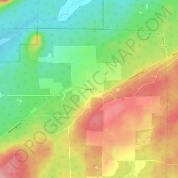
Nombre: Mapa topográfico Iron Belt, altitud, relieve.
Altitud media: 475 m
Altitud mínima: 419 m
Altitud máxima: 534 m
Gracias por apoyar a este sitio ❤️
Haz una donación
Haz una donación
Otros mapas topográficos
Haga clic en un mapa para ver su topografía, su altitud y su relieve.
Gracias por apoyar a este sitio ❤️
Haz una donación
Haz una donación
Hurley
United States > Wisconsin > Iron County
Hurley was at the center of a boundary dispute between Michigan and Wisconsin, culminating in a United States Supreme Court case in 1926, confirming Hurley belonging to Wisconsin. The Montreal River was mapped in detail in 1841 by Lieutenant Thomas Jefferson Cram of the United States Land Office Department of…
Altitud media: 455 m
Manitowish River
United States > Wisconsin > Iron County > Town of Mercer > Manitowish
Altitud media: 486 m
Gracias por apoyar a este sitio ❤️
Haz una donación
Haz una donación