
Gracias por apoyar a este sitio ❤️
Haz una donación
Haz una donación
Mapa topográfico Panichishte
Haga clic en el mapa para ver la altitud.
Gracias por apoyar a este sitio ❤️
Haz una donación
Haz una donación
Acerca de este mapa
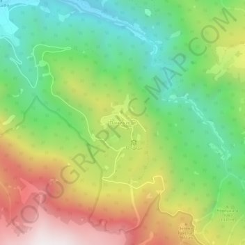
Nombre: Mapa topográfico Panichishte, altitud, relieve.
Lugar: Panichishte, Sapareva Bania, Kyustendil, 2650, Bulgaria (42.24540 23.27606 42.28540 23.31606)
Altitud media: 1.326 m
Altitud mínima: 775 m
Altitud máxima: 2.109 m
Gracias por apoyar a este sitio ❤️
Haz una donación
Haz una donación
Otros mapas topográficos
Haga clic en un mapa para ver su topografía, su altitud y su relieve.
Kyustendil
Kyustendil is a national balneological resort at an altitude of 600 metres. There are more than 40 mineral springs in the town. The waters have a high content of sulfite compounds. These are used for the treatment of the locomotory system, gynecological and other kinds of diseases. The resort region includes…
Altitud media: 939 m