
Haz una donación
Mapa topográfico Pistamata
Haga clic en el mapa para ver la altitud.
Haz una donación
Acerca de este mapa
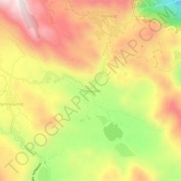
Nombre: Mapa topográfico Pistamata, altitud, relieve.
Altitud media: 553 m
Altitud mínima: 102 m
Altitud máxima: 907 m
Haz una donación
Otros mapas topográficos
Haga clic en un mapa para ver su topografía, su altitud y su relieve.
Sparta
Greece > Peloponnese, Western Greece and the Ionian > Laconia Regional Unit > Municipality of Sparta > Χαρίσιο
In 1907, the location of the sanctuary of Athena "of the Brazen House" (Χαλκίοικος, Chalkioikos) was determined to be on the acropolis immediately above the theatre. Though the actual temple is almost completely destroyed, the site has produced the longest extant archaic inscription in Laconia,…
Altitud media: 214 m
Ευρώτας
Greece > Peloponnese, Western Greece and the Ionian > Laconia Regional Unit
Logaras Spring supplies an anciently constructed catchment basin about the size of a pond, sometimes called a lake, which exits both to irrigation channels and to the Alpheios stream (not to be confused with the Alpheios river in the northwestern Peloponnese). The flow is copious except in times of drought. A…
Altitud media: 656 m
Sparta
Greece > Peloponnese, Western Greece and the Ionian > Laconia Regional Unit
Altitud media: 198 m
Municipal Unit of Faris
Greece > Peloponnese, Western Greece and the Ionian > Laconia Regional Unit
Altitud media: 732 m
Haz una donación
Municipality of Sparta
Greece > Peloponnese, Western Greece and the Ionian > Laconia Regional Unit
Altitud media: 699 m