
Mapa topográfico Marathon
Mapa interactivo
Haga clic en el mapa para ver la altitud.
Acerca de este mapa
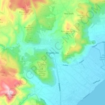
Nombre: Mapa topográfico Marathon, altitud, relieve.
Altitud media: 146 m
Altitud mínima: -1 m
Altitud máxima: 564 m
World records were not officially recognized by the IAAF until 1 January 2004; previously, the best times for the marathon were referred to as the 'world best'. Courses must conform to IAAF standards for a record to be recognized. However, marathon routes still vary greatly in elevation, course, and surface, making exact comparisons impossible. Typically, the fastest times are set over relatively flat courses near sea level, during good weather conditions and with the assistance of pacesetters.
Otros mapas topográficos
Haga clic en un mapa para ver su topografía, su altitud y su relieve.
Αρχή
Greece > Attica > Regional Unit of East Attica
Αρχή, Regional Unit of East Attica, Attica, Greece
Altitud media: 15 m
Gerakas Municipal Unit
Greece > Attica > Regional Unit of East Attica > Gerakas Municipal Unit
Gerakas Municipal Unit, Municipality of Pallini, Regional Unit of East Attica, Attica, 15344, Greece
Altitud media: 259 m
Municipality of Dionysos
Greece > Attica > Regional Unit of East Attica
Municipality of Dionysos, Regional Unit of East Attica, Attica, Greece
Altitud media: 385 m