
Gracias por apoyar a este sitio ❤️
Haz una donación
Haz una donación
Mapa topográfico Washington Terrace
Haga clic en el mapa para ver la altitud.
Gracias por apoyar a este sitio ❤️
Haz una donación
Haz una donación
Acerca de este mapa
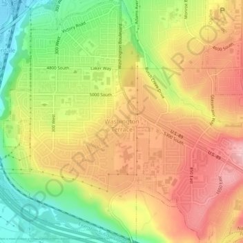
Nombre: Mapa topográfico Washington Terrace, altitud, relieve.
Lugar: Washington Terrace, Weber County, Utah, United States (41.15213 -111.99255 41.18534 -111.96103)
Altitud media: 1.411 m
Altitud mínima: 1.326 m
Altitud máxima: 1.482 m
Gracias por apoyar a este sitio ❤️
Haz una donación
Haz una donación
Otros mapas topográficos
Haga clic en un mapa para ver su topografía, su altitud y su relieve.
Ogden
United States > Utah > Weber County > Ogden
According to the United States Census Bureau, the city has an area of 26.6 square miles (69.0 km2), all land. Elevations in the city range from about 4,300 to 5,000 feet (1,300 to 1,500 m) above sea level.
Altitud media: 1.557 m