
Haz una donación
Mapa topográfico Qantara West
Haga clic en el mapa para ver la altitud.
Haz una donación
Acerca de este mapa
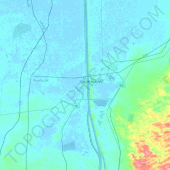
Nombre: Mapa topográfico Qantara West, altitud, relieve.
Lugar: Qantara West, Al Ismailiya, 41524, Egypt (30.69509 32.14961 31.01509 32.46961)
Altitud media: 8 m
Altitud mínima: -4 m
Altitud máxima: 92 m
Haz una donación
Otros mapas topográficos
Haga clic en un mapa para ver su topografía, su altitud y su relieve.
Suez Canal
Although the alleged difference in sea levels could be problematic for construction, the idea of finding a shorter route to the east remained alive. In 1830, F. R. Chesney submitted a report to the British government that stated that there was no difference in elevation and that the Suez Canal was feasible,…
Altitud media: 106 m
Suez Canal
Despite the construction challenges that could have been the result of the alleged difference in sea levels, the idea of finding a shorter route to the east remained alive. In 1830, General Francis Chesney submitted a report to the British government that stated that there was no difference in elevation and…
Altitud media: 106 m