
Haz una donación
Mapa topográfico Grassy
Haga clic en el mapa para ver la altitud.
Haz una donación
Acerca de este mapa
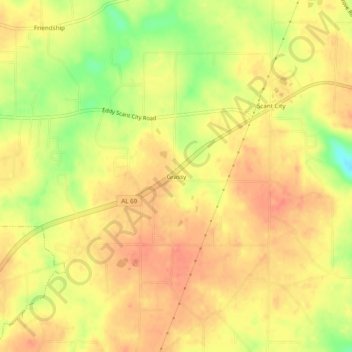
Nombre: Mapa topográfico Grassy, altitud, relieve.
Lugar: Grassy, Marshall County, Alabama, United States (34.33426 -86.45665 34.37426 -86.41665)
Altitud media: 309 m
Altitud mínima: 272 m
Altitud máxima: 326 m
Haz una donación
Otros mapas topográficos
Haga clic en un mapa para ver su topografía, su altitud y su relieve.
Albertville
United States > Alabama > Marshall County
According to the U.S. Census Bureau, Albertville has a total area of 27.0 square miles (69.9 km2), of which 0.1 square miles (0.3 km2), or 0.37%, are water. The city sits at an elevation of 1,060 feet (320 m) atop Sand Mountain, a plateau that in this area is about 15 miles (24 km) wide. The Tennessee Valley…
Altitud media: 309 m
Arab
United States > Alabama > Marshall County
Arab is located at an elevation of 1,100 feet (340 m) on top of Brindlee Mountain, near the southwest end of the Appalachian Plateau. The city is primarily in southern Marshall County; a small portion extends south into Cullman County. U.S. Route 231 runs north-to-south through Arab, and State Route 69 runs…
Altitud media: 314 m
Albertville
United States > Alabama > Marshall County
The city sits at an elevation of 1,060 feet (320 m) atop Sand Mountain, a plateau that in this area is about 15 miles (24 km) wide. The Tennessee Valley Divide passes through the southern part of the city. The majority of the city drains north to Short Creek, a tributary of the Tennessee River, while the…
Altitud media: 309 m
Haz una donación
Arab
United States > Alabama > Marshall County
Arab is located at an elevation of 1,100 feet (340 m) on top of Brindlee Mountain, near the southwest end of the Appalachian Plateau. The city is primarily in southern Marshall County; a small portion extends south into Cullman County. U.S. Route 231 runs north-to-south through Arab, and State Route 69 runs…
Altitud media: 314 m
Albertville
United States > Alabama > Marshall County
The city sits at an elevation of 1,060 feet (320 m) atop Sand Mountain, a plateau that in this area is about 15 miles (24 km) wide. The Tennessee Valley Divide passes through the southern part of the city. The majority of the city drains north to Short Creek, a tributary of the Tennessee River, while the…
Altitud media: 309 m