
Haz una donación
Mapa topográfico Guadalupe Peak
Haga clic en el mapa para ver la altitud.
Haz una donación
Guadalupe Peak
Guadalupe Peak, also known as Signal Peak, is the highest natural point in Texas, with an elevation of 8,751 feet (2,667 m) above sea level. It is located in Guadalupe Mountains National Park, and is part of the Guadalupe Mountains range in southeastern New Mexico and West Texas. The mountain is about 90 miles (140 km) east of El Paso and about 50 miles (80 km) southwest of Carlsbad, New Mexico. The peak rises more than 3,000 feet (910 m) above the arid floor of the Chihuahuan Desert.
Haz una donación
Acerca de este mapa
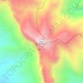
Nombre: Mapa topográfico Guadalupe Peak, altitud, relieve.
Altitud media: 2.150 m
Altitud mínima: 1.627 m
Altitud máxima: 2.651 m
Haz una donación
Otros mapas topográficos
Haga clic en un mapa para ver su topografía, su altitud y su relieve.
Van Horn
United States > Texas > Culberson County
According to the United States Census Bureau, the town has a total area of 2.8 square miles (7.3 km2), all land. Threemile Peak, elevation 4,868 feet (1,484 m), rises to the northwest overlooking the town.
Altitud media: 1.242 m
Guadalupe Mountains National Park
United States > Texas > Culberson County
The Guadalupe Mountains reach their highest point at Guadalupe Peak, the highest point in Texas, with an elevation of 8,751 feet (2,667 m). The range lies southeast of the Sacramento Mountains and east of the Brokeoff Mountains. The mountain range extends north-northwest and northeast from Guadalupe Peak in…
Altitud media: 1.484 m
Haz una donación
Van Horn
United States > Texas > Culberson County
According to the United States Census Bureau, the town has a total area of 2.8 square miles (7.3 km2), all land. Threemile Peak, elevation 4,868 feet (1,484 m), rises to the northwest overlooking the town.
Altitud media: 1.242 m
Van Horn
United States > Texas > Culberson County
According to the United States Census Bureau, the town has a total area of 2.8 square miles (7.3 km2), all land. Threemile Peak, elevation 4,868 feet (1,484 m), rises to the northwest overlooking the town.
Altitud media: 1.242 m