
Haz una donación
Mapa topográfico Craponne-sur-Arzon
Haga clic en el mapa para ver la altitud.
Haz una donación
Craponne-sur-Arzon
Located on a granitic plateau mostly situated at more than 900 meters elevation, the commune has a minimum elevation of 771 meters, near the Bois de l'Or along the river Ance in the south-east part of the commune. Its maximum elevation is about 1063 meters, the highest point being located near the place called Le Fêtre, in the north of the town.
Haz una donación
Acerca de este mapa
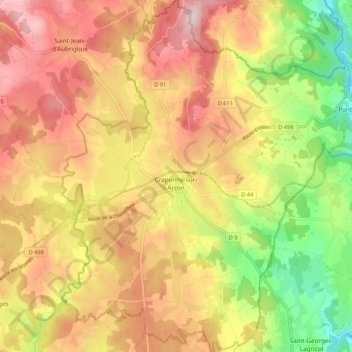
Nombre: Mapa topográfico Craponne-sur-Arzon, altitud, relieve.
Altitud media: 929 m
Altitud mínima: 772 m
Altitud máxima: 1.057 m
Haz una donación
Otros mapas topográficos
Haga clic en un mapa para ver su topografía, su altitud y su relieve.
Haz una donación
Cheneville
France > Auvergne-Rhône-Alpes > Haute-Loire > Varennes-Saint-Honorat
Altitud media: 1.055 m
Laniac
France > Auvergne-Rhône-Alpes > Haute-Loire > Siaugues-Sainte-Marie > Siaugues-Saint-Romain
Altitud media: 909 m
Haz una donación
Haz una donación
Haz una donación