
Mapa topográfico Municipal Unit of Nea Kios
Mapa interactivo
Haga clic en el mapa para ver la altitud.
Acerca de este mapa
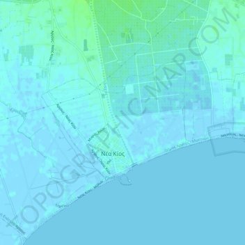
Nombre: Mapa topográfico Municipal Unit of Nea Kios, altitud, relieve.
Altitud media: 2 m
Altitud mínima: -3 m
Altitud máxima: 9 m
Otros mapas topográficos
Haga clic en un mapa para ver su topografía, su altitud y su relieve.
Nafplio
Greece > Peloponnese, Western Greece and the Ionian > Argolis Regional Unit > Municipal Unit of Nafplio
Nafplio, Municipal Unit of Nafplio, Municipality of Nafplio, Argolis Regional Unit, Peloponnese Region, Peloponnese, Western Greece and the Ionian, 211 00, Greece
Altitud media: 36 m
Myli
Greece > Peloponnese, Western Greece and the Ionian > Argolis Regional Unit > Municipal Unit of Lerna
Myli, Municipal Unit of Lerna, Municipality of Argos and Mykines, Argolis Regional Unit, Peloponnese Region, Peloponnese, Western Greece and the Ionian, 212 00, Greece
Altitud media: 31 m
Municipal Unit of Mykines
Greece > Peloponnese, Western Greece and the Ionian > Argolis Regional Unit
Municipal Unit of Mykines, Municipality of Argos and Mykines, Argolis Regional Unit, Peloponnese Region, Peloponnese, Western Greece and the Ionian, Greece
Altitud media: 312 m
Kilada
Greece > Peloponnese, Western Greece and the Ionian > Argolis Regional Unit > Municipal Unit of Kranidi
Kilada, Municipal Unit of Kranidi, Municipality of Ermionida, Argolis Regional Unit, Peloponnese Region, Peloponnese, Western Greece and the Ionian, 213 00, Greece
Altitud media: 17 m