
Haz una donación
Mapa topográfico Bakewell
Haga clic en el mapa para ver la altitud.
Haz una donación
Acerca de este mapa
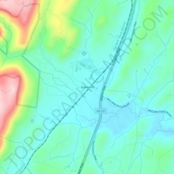
Nombre: Mapa topográfico Bakewell, altitud, relieve.
Altitud media: 269 m
Altitud mínima: 204 m
Altitud máxima: 468 m
Haz una donación
Otros mapas topográficos
Haga clic en un mapa para ver su topografía, su altitud y su relieve.
Chattanooga
United States > Tennessee > Hamilton County
Chattanooga showcases a diverse and striking topography that is defined by its position within the Appalachian region. Nestled between the rugged Ridge-and-Valley Appalachians and the Cumberland Plateau, the city is framed by dramatic hills and valleys, creating a visually compelling landscape. The Tennessee…
Altitud media: 331 m
Haz una donación
Haz una donación
Haz una donación
Chattanooga
United States > Tennessee > Hamilton County
According to the United States Census Bureau, the city has a total area of 144.6 square miles (374.4 km2), of which 137.1 square miles (355.2 km2) are land and 7.4 square miles (19.2 km2), or 5.12%, are water. The most prominent natural features in and around Chattanooga are the Tennessee River and the…
Altitud media: 331 m
Haz una donación
Chattanooga
United States > Tennessee > Hamilton County
The city, with a downtown elevation of about 680 feet (210 m), is at the transition between the ridge-and-valley portion of the Appalachian Mountains and the Cumberland Plateau. Its official nickname is "Scenic City", alluding to the surrounding by mountains and ridges. Unofficial nicknames include "River…
Altitud media: 331 m
Haz una donación