
Haz una donación
Mapa topográfico Prakasam
Haga clic en el mapa para ver la altitud.
Haz una donación
Prakasam
The Nallamalas and the Veligondas are the major hill ranges in the district. The Nallamalas consist of a range of continuous fairly steep hills with an average elevation of about 620 meters above sea level. There are two passes in the Nallamalas namely, the Nandi Kanuma and Manbala Kanuma. The Nandi Kanuma passes from Bellary (in Karnataka) via Kurnool, Dornala, and Yerragondapalem to Markapur. The portions of Veligondas stand prominently as two continuous parallel ranges of fairly steep hills running in a north-south direction with a wide valley in between. The water from the eastern range of hills drains in a northerly direction to the Gundlakamma river.
Haz una donación
Acerca de este mapa
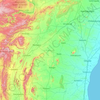
Nombre: Mapa topográfico Prakasam, altitud, relieve.
Lugar: Prakasam, Andhra Pradesh, India (15.02198 78.73648 16.30638 80.27278)
Altitud media: 204 m
Altitud mínima: 0 m
Altitud máxima: 956 m
Haz una donación
Otros mapas topográficos
Haga clic en un mapa para ver su topografía, su altitud y su relieve.
Guntakal
India > Andhra Pradesh > Guntakal
Guntakal is located at 15°10′N 77°23′E / 15.17°N 77.38°E / 15.17; 77.38. It has an average elevation of 432 metres (1,417 ft).
Altitud media: 445 m
Vijayawada
Vijayawada lies on the banks of Krishna river, covered by hills and canals. and at an altitude of 11 m (36 ft) above sea level. Three canals originating from the north side of the Prakasam Barrage reservoir — Eluru, Bandar, and Ryves — flow through the city.
Altitud media: 36 m
Haz una donación
Haz una donación
Haz una donación
Haz una donación
Haz una donación
Machilipatnam
India > Andhra Pradesh > Machilipatnam > Machilipatnam
Machilipatnam city is at 16°10′N 81°08′E / 16.17°N 81.13°E / 16.17; 81.13 on the southeast coast of India and in the east coast of Andhra Pradesh. The city has an average elevation of 14 meters (45 feet).
Altitud media: 4 m
Haz una donación
Mangalagiri
India > Andhra Pradesh > Mangalagiri > Mangalagiri
Mangalagiri is located at 16°26′N 80°33′E / 16.43°N 80.55°E / 16.43; 80.55. It has an average elevation of 29.08 m (95.4 ft).It is located 26 kilometres (16 mi) north east of the district headquarters, Guntur, and just 10 km (6.2 mi) south west of Vijayawada and also 30 km (19 mi) to the north…
Altitud media: 29 m
Haz una donación
Haz una donación
Haz una donación
Haz una donación