
Haz una donación
Mapa topográfico Surigao City
Haga clic en el mapa para ver la altitud.
Haz una donación
Surigao City
Surigao City is marked by rolling hills that gently buffers its eastern and western boundaries. To the south-west towers the Kabangkaan Ridge which divides the city from the municipality of San Francisco (formerly Anao-aon). Kinabutan River (otherwise known as Surigao River) meanders Surigao valley before it empties to the Surigao tidal basin, a shrinking mangrove swamp fast overtaken by the city's expansion. It has an average elevation of 19 meters or 65.5 ft. above sea level. The highest elevation on the mainland at the Kabangkaan Ridge has a peak elevation of 465 meters above sea level. Along the border of Tagana-an is Mapawa Peak with an elevation of 245 meters above sea level. Barangays Cabongbongan, Nabago and Capalayan are at the foot of its slopes.
Haz una donación
Acerca de este mapa
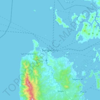
Nombre: Mapa topográfico Surigao City, altitud, relieve.
Lugar: Surigao City, Surigao del Norte, Caraga, 8400, Philippines (9.63050 125.33357 9.95050 125.65357)
Altitud media: 40 m
Altitud mínima: -1 m
Altitud máxima: 959 m
Haz una donación
Otros mapas topográficos
Haga clic en un mapa para ver su topografía, su altitud y su relieve.
Haz una donación
Haz una donación
Haz una donación
Haz una donación
Haz una donación
Haz una donación