
Haz una donación
Mapa topográfico Serow
Haga clic en el mapa para ver la altitud.
Haz una donación
Acerca de este mapa
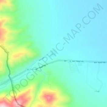
Nombre: Mapa topográfico Serow, altitud, relieve.
Altitud media: 1.654 m
Altitud mínima: 1.560 m
Altitud máxima: 1.993 m
Haz una donación
Otros mapas topográficos
Haga clic en un mapa para ver su topografía, su altitud y su relieve.
Urmia
Iran > West Azerbaijan Province > Urumia County
The city lies at an altitude of 1,330 metres (4,360 ft) above sea level along the Shahar River on the Urmia Plain. Lake Urmia, one of the world's largest salt lakes, lies to the east of the city, and the border with Turkey lies to the west.
Altitud media: 1.386 m
Haz una donación