
Gracias por apoyar a este sitio ❤️
Haz una donación
Haz una donación
Mapa topográfico Mansfield
Haga clic en el mapa para ver la altitud.
Gracias por apoyar a este sitio ❤️
Haz una donación
Haz una donación
Acerca de este mapa
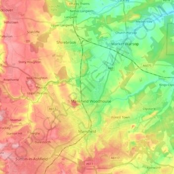
Nombre: Mapa topográfico Mansfield, altitud, relieve.
Altitud media: 117 m
Altitud mínima: 42 m
Altitud máxima: 197 m
Gracias por apoyar a este sitio ❤️
Haz una donación
Haz una donación
Otros mapas topográficos
Haga clic en un mapa para ver su topografía, su altitud y su relieve.
Gracias por apoyar a este sitio ❤️
Haz una donación
Haz una donación
Hucknall
United Kingdom > England > Nottinghamshire > Ashfield
Hucknall Airfield, built in 1916, became RAF Hucknall. From 1927, Rolls-Royce began using the airfield for flight tests. During World War II, the aerodrome at Hucknall launched the first flight of a P-51 Mustang fitted with a Rolls-Royce Merlin Engine. The Merlin, replacing the earlier Allison V-1710 engine,…
Altitud media: 104 m
Gracias por apoyar a este sitio ❤️
Haz una donación
Haz una donación