
Haz una donación
Mapa topográfico Mount Bromo
Haga clic en el mapa para ver la altitud.
Haz una donación
Acerca de este mapa
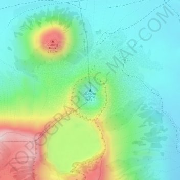
Nombre: Mapa topográfico Mount Bromo, altitud, relieve.
Lugar: Mount Bromo, Pasuruan, Indonesia (-7.94212 112.95293 -7.94202 112.95303)
Altitud media: 2.239 m
Altitud mínima: 2.110 m
Altitud máxima: 2.504 m
Haz una donación
Otros mapas topográficos
Haga clic en un mapa para ver su topografía, su altitud y su relieve.
Pulau Bali
Bali features a diverse topography shaped by a volcanic origin, which significantly influences its landscapes and climate. The island is dominated by a central mountain range that runs from west to east, with Mount Agung, reaching an elevation of approximately 10,308 feet, standing as the highest peak and a…
Altitud media: 122 m
Haz una donación
Special Capital Region of Jakarta
Jakarta lies in a low and flat alluvial plain, ranging from −2 to 91 m (−7 to 299 ft) with an average elevation of 8 m (26 ft) above sea level with historically extensive swampy areas. Some parts of the city have been constructed on reclaimed tidal flats that occur in around the area. Thirteen rivers flow…
Altitud media: 5 m
Lombok
Indonesia > West Nusa Tenggara
The island's topography is dominated by the centrally-located stratovolcano Mount Rinjani, the second-highest volcano in Indonesia, which rises to 3,726 metres (12,224 ft), making Lombok the 8th-highest island. The most recent eruption of Rinjani occurred in September 2016 at Gunung Barujari. In a 2010…
Altitud media: 192 m
Borneo
Before sea levels rose at the end of the last Ice Age, Borneo was part of the mainland of Asia, forming, with Java and Sumatra, the upland regions of a peninsula that extended east from present day Indochina. The South China Sea and Gulf of Thailand now submerge the former low-lying areas of the peninsula.…
Altitud media: 141 m
Haz una donación
Bali
Bali's central mountains include several peaks over 2,000 metres (6,600 feet) in elevation and active volcanoes such as Mount Batur. The highest is Mount Agung (3,031 m, 9,944 ft), known as the "mother mountain", which is an active volcano rated as one of the world's most likely sites for a massive eruption…
Altitud media: 88 m
Haz una donación
East Java
East Java has a tropical monsoon and savanna climate at lower elevation and subtropical at higher elevation. Compared with the western part of Java Island, East Java in general has less rainfall. Average rainfall is 1,900 mm per year, with a rainy season during the 100 days. The average temperature ranges…
Altitud media: 62 m
Haz una donación
Bekasi
The City of Bekasi is a part of the Bekasi river basin, located in the downstream area of the basin with slopes ranging from 0 to 2% and elevations between 11 meters to 81 meters above sea level. The city of Bekasi is part of the Bekasi river basin and is located in the downstream area of the basin, with a…
Altitud media: 32 m
Borneo
Before sea levels rose at the end of the last ice age, Borneo was part of the mainland of Asia, forming, with Java and Sumatra, the upland regions of a peninsula that extended east from present day Indochina. The South China Sea and Gulf of Thailand now submerge the former low-lying areas of the peninsula.…
Altitud media: 141 m
Haz una donación
Haz una donación
Haz una donación
Semarang
Semarang is located on the northern coast of Java. The city of Semarang is one of the important cities located on the north coast of Java and as the main hub connecting Jakarta and Surabaya, and cities in the southern interior of Java Surakarta and Yogyakarta. Semarang City has a height ranging from 2 m (6.6…
Altitud media: 107 m
Haz una donación
Temanggung
Temanggung Regency is located on the volcanic Dieng Plateau with an average elevation between 500 and 1450 meters. It is landlocked. The volcanoes Mount Sundoro and Mount Sumbing rise on its border with the Wonosobo Regency. Its major drainage system is the Progo River and its tributaries.
Altitud media: 771 m
Bali
Bali's central mountains include several peaks over 2,000 metres (6,600 feet) in elevation and active volcanoes such as Mount Batur. The highest is Mount Agung (3,031 m; 9,944 ft), known as the "mother mountain", which is an active volcano rated as one of the world's most likely sites for a massive eruption…
Altitud media: 88 m
Haz una donación
North Sulawesi
The province's capital and largest city is Manado, which is also the main gateway and the economic center of the province. Other major towns includes Tomohon and Bitung in the northern (Minahasa) half of the province, and Kotamobagu in the southern (Bolaang Mongondow) half. There are 41 mountains with an…
Altitud media: 28 m
Haz una donación
Haz una donación
Bekasi
The City of Bekasi is a part of the Bekasi river basin, located in the downstream area of the basin with slopes ranging from 0 to 2% and elevations between 11 meters to 81 meters above sea level. The city of Bekasi is part of the Bekasi river basin and is located in the downstream area of the basin, with a…
Altitud media: 32 m
Haz una donación
Special Capital Region of Jakarta
Jakarta lies in a low and flat alluvial plain, ranging from −2 to 91 m (−7 to 299 ft) with an average elevation of 8 m (26 ft) above sea level with historically extensive swampy areas. Some parts of the city have been constructed on reclaimed tidal flats that occur in around the area. Thirteen rivers flow…
Altitud media: 5 m
Denpasar
Denpasar is located at an elevation of 4 m (13 ft) above sea level. While the total area of 127.78 km2 or 2.18% of the total area of Bali Province. From the use of land, 2,768 hectares of land are paddy, 10,001 hectares are dry land, while the remaining land area is 9 hectares.
Altitud media: 7 m
Haz una donación
Haz una donación
Haz una donación
Haz una donación
Haz una donación
Purworejo
Railway in Purworejo is part of the southern Java railway system. Five train stations have served various areas in Purworejo. The primary station is Kutoarjo in Kutoarjo District. Located at an altitude of +16 meters, Kutoarjo Station is a large type A railway station that has seven (7) fully functioning lines…
Altitud media: 212 m
Wonosobo
Wonosobo has an elevation moderated tropical rainforest climate (Af) with moderate rainfall from July to September and heavy to very heavy rainfall in the remaining months. The following climate data is for the town of Wonosobo.
Altitud media: 876 m
Aceh Tengah
Central Aceh District is a highland area with an altitude between 200 – 2600 metres above sea level and with an area of 4,527.53 km2.
Altitud media: 936 m
Haz una donación
Special Capital Region of Jakarta
Jakarta lies in a flat, low alluvial plain, ranging from −2 to 91 metres (−6.6 to 298.6 feet) with an average elevation of 8 metres (26 feet) above sea level with historically extensive swampy areas. Some parts of the city have been constructed on reclaimed tidal flats that occur around the area. Thirteen…
Altitud media: 5 m
Batu
In the 19th century, the Dutch East Indies government developed Batu as a mountain resort. Villas and resort facilities were built in Batu during the period. Most of the topography of Batu City is dominated by highland and hilly terrain with valleys running down mountain slopes. In northern Batu, there is a…
Altitud media: 1.365 m
Haz una donación
Semarang
Semarang is located on the northern coast of Java. The city of Semarang is one of the important cities located on the north coast of Java and as the main hub connecting Jakarta and Surabaya, and cities in the southern interior of Java Surakarta and Yogyakarta. Semarang City has a height ranging from 2 m (6.6…
Altitud media: 107 m
Tasikmalaya
The city is located in the mountainous Priangan region of Java at an elevation of 351 metres (1,151 feet).
Altitud media: 367 m
Haz una donación
Haz una donación
Haz una donación
Haz una donación
Wakatobi National Park
Indonesia > Southeast Sulawesi
It consists of four larger islands: Wangi-Wangi, Kaledupa, Tomia and Binongko, as well as many small islands such as Tokobao, North Lintea, South Lintea, Kampenaune, Hoga and Tolandono. The highest elevation is 274 metres (899 ft) on Wangi-Wangi, followed by Lagole Hill (271m) on Tomia, Terpadu Hill (222 m) on…
Altitud media: 1 m
Sulawesi
The lowland forests on the island have mostly been removed. Because of the relative geological youth of the island and its dramatic and sharp topography, the lowland areas are naturally limited in their extent. The past decade has seen dramatic conversion of this rare and endangered habitat. The island also…
Altitud media: 95 m
Haz una donación
Lombok
Indonesia > West Nusa Tenggara
The island's topography is dominated by the centrally-located stratovolcano Mount Rinjani, the second-highest volcano in Indonesia, which rises to 3,726 metres (12,224 ft), making Lombok the 8th-highest island. The most recent eruption of Rinjani occurred in September 2016 at Gunung Barujari. In a 2010…
Altitud media: 192 m
Haz una donación