
Gracias por apoyar a este sitio ❤️
Haz una donación
Haz una donación
Mapa topográfico Chiswell
Haga clic en el mapa para ver la altitud.
Gracias por apoyar a este sitio ❤️
Haz una donación
Haz una donación
Acerca de este mapa
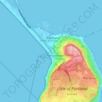
Nombre: Mapa topográfico Chiswell, altitud, relieve.
Lugar: Chiswell, Dorset, England, DT5 1AN, United Kingdom (50.54205 -2.46855 50.58205 -2.42855)
Altitud media: 24 m
Altitud mínima: -5 m
Altitud máxima: 145 m
Gracias por apoyar a este sitio ❤️
Haz una donación
Haz una donación
Otros mapas topográficos
Haga clic en un mapa para ver su topografía, su altitud y su relieve.
Isle of Portland
United Kingdom > England > Dorset > Wyke Regis
In Museums Without Walls, Jonathan Meades declares that "Portland is a bulky chunk of geological, social, topographical and demographic weirdness. It is the obverse of a beauty spot. 'Beauty' in this construction implies the picturesque. Portland is gloriously bereft of this quality. It is awesome. There is…
Altitud media: 11 m
Gracias por apoyar a este sitio ❤️
Haz una donación
Haz una donación
Gracias por apoyar a este sitio ❤️
Haz una donación
Haz una donación
Gracias por apoyar a este sitio ❤️
Haz una donación
Haz una donación
Gracias por apoyar a este sitio ❤️
Haz una donación
Haz una donación