
Mapa topográfico Heath
Haga clic en el mapa para ver la altitud.
Acerca de este mapa
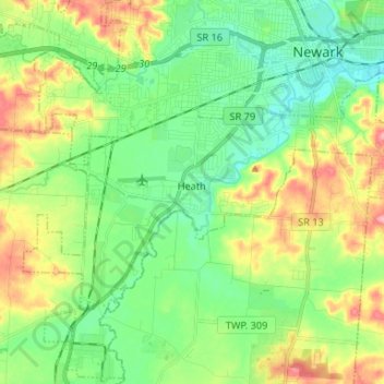
Nombre: Mapa topográfico Heath, altitud, relieve.
Lugar: Heath, Licking County, Ohio, United States (39.99028 -82.50248 40.05240 -82.37088)
Altitud media: 281 m
Altitud mínima: 241 m
Altitud máxima: 354 m
Otros mapas topográficos
Haga clic en un mapa para ver su topografía, su altitud y su relieve.
Etna
United States > Ohio > Licking County
Etna (formerly Carthage) is an unincorporated community and census-designated place (CDP) in Licking County, Ohio, United States. As of the 2020 census it had a population of 1,209. It lies at an elevation of 1,069 feet (326 m) at the intersection of U.S. Route 40 and State Route 310. It was listed as a…
Altitud media: 321 m