
Haz una donación
Mapa topográfico Dêqên County
Haga clic en el mapa para ver la altitud.
Haz una donación
Dêqên County
Being located at an altitude of 3,300 metres (10,800 ft), Deqin lies in the transition between a subtropical highland climate (Köppen Cwb) and humid continental climate (Köppen Dwb), which is remarkable for its latitude. Although mean maximum temperatures, as in Lhasa and Shigatse, stay above freezing year-round, minima are below freezing from November to March, and temperatures average −1.4 °C (29.5 °F) in January, 13.6 °C (56.5 °F) in July, while the annual mean is 6.32 °C (43.4 °F). The town is nonetheless a little warmer during the winter than Shangri-La County to the east despite being slightly higher in elevation, due to its more southerly aspect. Rainfall is concentrated between June and September, accounting for nearly 60% of the annual total of 640 mm (25.2 in); snowfall is rare but still causes major transport problems in the winter. With monthly percent possible sunshine ranging from 29% in July to 62% in December, the county seat receives 1,989 hours of bright sunshine annually, with autumn and winter sunnier than spring and summer.
Haz una donación
Acerca de este mapa
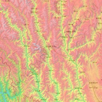
Nombre: Mapa topográfico Dêqên County, altitud, relieve.
Lugar: Dêqên County, Diqing, Yunnan, China (27.55823 98.59286 29.22572 99.52114)
Altitud media: 3.590 m
Altitud mínima: 1.022 m
Altitud máxima: 6.429 m
Haz una donación
Otros mapas topográficos
Haga clic en un mapa para ver su topografía, su altitud y su relieve.
Shangri-La
China > Yunnan > Shangri-La > Jiantang
Shangri-La has either a dry-winter, warm-summer humid continental climate (Köppen climate classification: Dwb), or a dry-winter subtropical highland climate (Köppen climate classification: Cwb), both of which are unusually cool by Yunnan standards due to the high elevation, which ranges between 2,700 and…
Altitud media: 3.674 m
Pingbian
China > Yunnan > Pingbian Miao Autonomous County
Pingbian County has a mild subtropical highland climate (Köppen Cwb) influenced by its elevation, with short, mild, dry winters and warm, humid summers. The monthly 24-hour average temperature ranges from 9.2 °C (48.6 °F) in January to 21.3 °C (70.3 °F) in July, and the annual mean is 16.3 °C (61.3 °F).…
Altitud media: 1.167 m
Haz una donación
Haz una donación
Tengchong
Situated at the southwestern end of the (transversely faulted) Hengduan Mountains, Tengchong topographically assumes the form of a horseshoe with the opening facing the south. The easternmost sources of the Irrawaddy River issue from the high mountains at the summit of Mount Danaozi of Gaoligong Mountain,…
Altitud media: 1.770 m
Haz una donación
Haz una donación