
Haz una donación
Mapa topográfico Sokoru
Haga clic en el mapa para ver la altitud.
Haz una donación
Sokoru
The altitude of this woreda ranges from 1160 to 2940 meters above sea level; the highest points include Ali Shashema, Ali Derar and Kumbi. Perennial rivers include the Gilgel Gibe a tributary of the Gibe, and the Kawar; seasonal streams include the Melka Luku. A survey of the land in this woreda shows that 36.6% is arable or cultivable, 16.8% pasture, 17.2% forest, and the remaining 29.4% is built-up or degraded. The Abelti-Gibe State Forest covers 159 square kilometers of the forested area. Teff is one important cash crop. Although coffee is another important cash crop of this woreda, less than 20 square kilometers are planted with this crop.
Haz una donación
Acerca de este mapa
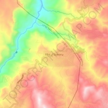
Nombre: Mapa topográfico Sokoru, altitud, relieve.
Lugar: Sokoru, Jimma, Oromia Region, Ethiopia (7.88568 37.37791 7.96568 37.45791)
Altitud media: 1.827 m
Altitud mínima: 1.343 m
Altitud máxima: 2.216 m
Haz una donación
Otros mapas topográficos
Haga clic en un mapa para ver su topografía, su altitud y su relieve.
Bale Mountains National Park
The Bale Mountains play a vital role in climate control of the region by attracting large amounts of orographic rainfall, which has obvious implications for livestock and agricultural production. Some 600–1,000 mm (24–39 in) fall annually in the lower altitude areas, while 1,000–1,400 mm (39–55 in)…
Altitud media: 2.612 m
Haz una donación
Lake Langano
Lake Langano (Oromo: Hora Langaanoo, Amharic: ላንጋኖ ሐይቅ) is a lake in the Oromia Region of Ethiopia, exactly 200 kilometers by road south of the capital, Addis Ababa, on the border between the East Shewa Zone and Arsi Zones. It is located to the east of Lake Abijatta in the Main Ethiopian Rift at…
Altitud media: 1.625 m
Haz una donación