
Haz una donación
Mapa topográfico Mutrah
Haga clic en el mapa para ver la altitud.
Haz una donación
Acerca de este mapa
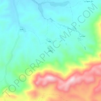
Nombre: Mapa topográfico Mutrah, altitud, relieve.
Lugar: Mutrah, Hidaybu District, Socotra Governorate, Yemen (12.54303 54.23276 12.58303 54.27276)
Altitud media: 218 m
Altitud mínima: 55 m
Altitud máxima: 588 m
Haz una donación
Otros mapas topográficos
Haga clic en un mapa para ver su topografía, su altitud y su relieve.
عبد الكوري
The terrain of Abd al-Kuri is semi-arid, with little vegetation; annual monsoons, originating from the Indian Subcontinent, deliver vital precipitation each year. Two ranges of large hills, separating near the island's centre, run nearly the entire east-west length of the island. The northern coast consists…
Altitud media: 7 m
Socotra
The main island has three geographical terrains: the narrow coastal plains, a limestone plateau with karst topography and the Hajhir Mountains. The mountains rise to 1,503 metres (4,931 ft). The island is about 125 kilometres (78 mi) long and 45 kilometres (28 mi) north to south.
Altitud media: 64 m