
Gracias por apoyar a este sitio ❤️
Haz una donación
Haz una donación
Mapa topográfico Marlow
Haga clic en el mapa para ver la altitud.
Gracias por apoyar a este sitio ❤️
Haz una donación
Haz una donación
Acerca de este mapa
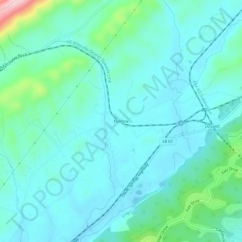
Nombre: Mapa topográfico Marlow, altitud, relieve.
Altitud media: 286 m
Altitud mínima: 239 m
Altitud máxima: 517 m
Gracias por apoyar a este sitio ❤️
Haz una donación
Haz una donación
Otros mapas topográficos
Haga clic en un mapa para ver su topografía, su altitud y su relieve.
Oak Ridge
United States > Tennessee > Anderson County
The highest point is Melton Hill (35°54′35″N 84°18′19″W / 35.90962°N 84.30525°W / 35.90962; -84.30525) on the DOE reservation, at elevation 1,356 feet (413 m).
Altitud media: 290 m
Gracias por apoyar a este sitio ❤️
Haz una donación
Haz una donación
Gracias por apoyar a este sitio ❤️
Haz una donación
Haz una donación
Oak Ridge
United States > Tennessee > Anderson County
The highest point is Melton Hill (35°54′35″N 84°18′19″W / 35.90962°N 84.30525°W / 35.90962; -84.30525) on the DOE reservation, at elevation 1,356 feet (413 m).
Altitud media: 290 m
Gracias por apoyar a este sitio ❤️
Haz una donación
Haz una donación