
Gracias por apoyar a este sitio ❤️
Haz una donación
Haz una donación
Mapa topográfico Pettino
Haga clic en el mapa para ver la altitud.
Gracias por apoyar a este sitio ❤️
Haz una donación
Haz una donación
Pettino
It stands at an elevation of 1074 metres above sea level. At the time of the Istat census of 2001, it had only 74 inhabitants.
Gracias por apoyar a este sitio ❤️
Haz una donación
Haz una donación
Acerca de este mapa
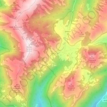
Nombre: Mapa topográfico Pettino, altitud, relieve.
Lugar: Pettino, Campello sul Clitunno, Perugia, Umbria, 06042, Italy (42.84289 12.79229 42.88289 12.83229)
Altitud media: 1.141 m
Altitud mínima: 730 m
Altitud máxima: 1.417 m
Gracias por apoyar a este sitio ❤️
Haz una donación
Haz una donación