
Haz una donación
Mapa topográfico Verecke Pass
Haga clic en el mapa para ver la altitud.
Haz una donación
Verecke Pass
The pass is located in the Carpathian Mountains just where the oblasts of Lviv and Transcarpathia meet, on the spine of the Northeastern Carpathians, between the Latorica (or Latorytsia) and Opir river valleys and at the river divide or watershed between the Latorytsia and the Stryi. It has an elevation of 841 meters.
Haz una donación
Acerca de este mapa
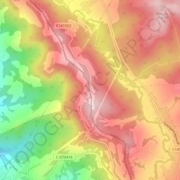
Nombre: Mapa topográfico Verecke Pass, altitud, relieve.
Altitud media: 749 m
Altitud mínima: 564 m
Altitud máxima: 868 m
Haz una donación
Otros mapas topográficos
Haga clic en un mapa para ver su topografía, su altitud y su relieve.
Lviv
Lviv is on the edge of the Roztochia Upland, about 70 kilometres (43 miles) east of Polish border and 160 km (99 mi) north of the eastern Carpathian Mountains. The average altitude of Lviv is 296 metres (971 feet) above sea level. Its highest point is the Vysokyi Zamok (High Castle), 409 meters (1342 feet)…
Altitud media: 309 m
Lviv
Lviv is on the edge of the Roztochia Upland, about 70 kilometres (43 miles) east of the Polish border and 160 km (99 mi) north of the eastern Carpathian Mountains. The average altitude of Lviv is 296 metres (971 feet) above sea level. Its highest point is the Vysokyi Zamok (High Castle), 409 meters (1,342…
Altitud media: 309 m
Lviv
Lviv is on the edge of the Roztochia Upland, about 70 kilometres (43 miles) east of Polish border and 160 km (99 mi) north of the eastern Carpathian Mountains. The average altitude of Lviv is 296 metres (971 feet) above sea level. Its highest point is the Vysokyi Zamok (High Castle), 409 meters (1342 feet)…
Altitud media: 309 m
Haz una donación
Haz una donación
Haz una donación
Lviv
Lviv is on the edge of the Roztochia Upland, about 70 kilometres (43 miles) east of the Polish border and 160 km (99 mi) north of the eastern Carpathian Mountains. The average altitude of Lviv is 296 metres (971 feet) above sea level. Its highest point is the Vysokyi Zamok (High Castle), 409 meters (1,342…
Altitud media: 309 m
Haz una donación
Haz una donación
Haz una donación
Haz una donación
Skhidnytsia
Skhidnytsia located at an altitude of 600 metres (2,000 ft) – 900 metres (3,000 ft) above sea level. The mountains around the town reach a height of 823 metres (2,700 ft).
Altitud media: 623 m
Haz una donación
Haz una donación
Haz una donación
Ландшафтний заказник місцевого значення «Романівський»
Ukraine > Lviv Oblast > Romaniv
Altitud media: 414 m
Haz una donación
Haz una donación
Haz una donación