
Haz una donación
Mapa topográfico Jomsom
Haga clic en el mapa para ver la altitud.
Haz una donación
Jomsom
Jomsom (Nepali: जोमसोम), (Ward No. 4 of Gharpajhong Rural Municipality) also known as Dzongsam (New Fort), is the centre of Gharapjhong rural municipality in Mustang district and a former independent village development committee situated at an altitude of about 2,700 metres (8,900 ft) in Gandaki Province of western Nepal. The soaring peaks of Dhaulagiri and Nilgiri form a backdrop to the town straddling the Kali Gandaki River, which flows right through the centre of Jomsom. Along the banks of the Kali Gandaki, black fossilised stones called shaligram, considered as an iconic symbol and reminder of the god Vishnu in the Hindu culture, can be found. Such stones are believed to be found only in the Kali Gandaki, and are considered holy by Hindus.
Haz una donación
Acerca de este mapa
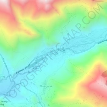
Nombre: Mapa topográfico Jomsom, altitud, relieve.
Lugar: Jomsom, Gharapjhong, Mustang, Gandaki Province, Nepal (28.76381 83.71050 28.80381 83.75050)
Altitud media: 3.061 m
Altitud mínima: 2.695 m
Altitud máxima: 3.802 m
Haz una donación
Otros mapas topográficos
Haga clic en un mapa para ver su topografía, su altitud y su relieve.