
Haz una donación
Mapa topográfico Kecamatan Mahu
Haga clic en el mapa para ver la altitud.
Haz una donación
Acerca de este mapa
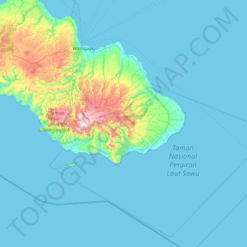
Nombre: Mapa topográfico Kecamatan Mahu, altitud, relieve.
Altitud media: 99 m
Altitud mínima: 0 m
Altitud máxima: 1.159 m
Haz una donación
Otros mapas topográficos
Haga clic en un mapa para ver su topografía, su altitud y su relieve.
Komodo National Park
Indonesia > East Nusa Tenggara > Manggarai Barat
The park comprises a coastal section of western Flores, the three larger islands of Komodo, Padar and Rinca, 26 smaller islands and the surrounding waters of the Sape Straights. The islands of the national park are of volcanic origin. The terrain is generally rugged, characterized by rounded hills, with…
Altitud media: 38 m
Haz una donación
Haz una donación
Haz una donación
Haz una donación
Rote Ndao
Indonesia > East Nusa Tenggara
The regency is surrounded by water, bordering the Savu Sea to the north, the Indian Ocean to the south and west, and the Pukuafu Strait to the east. It is composed of 107 islands, 8 of which are inhabited and 99 are uninhabited. The topography varies from flat make up 35% of its territory to hills around 25%,…
Altitud media: 14 m
Haz una donación
Haz una donación
Haz una donación
Haz una donación
Taman Gelora
Indonesia > East Nusa Tenggara > Sumba Barat > Waikabubak > Kampung Ngadu Motora
Altitud media: 417 m
Haz una donación
Haz una donación