
Haz una donación
Mapa topográfico Yuanyang County
Haga clic en el mapa para ver la altitud.
Haz una donación
Yuanyang County
It covers an area of 2,200 km2 (850 sq mi) and has a population of approximately 365,000 (2002), of which 88% belong to ethnic minorities and 95% is associated with agriculture. The majority of the inhabitants of the county are from the Hani ethnic group. The GDP of Yuanyang county in 2021 was 9,312 million Yuan. The administrative seat of the county is the town of Nansha (a.k.a. New Yuanyang) down in the Red River valley at an elevation of 240 meters. It is situated 12 km (7.5 mi) towards the north-east of the former administrative seat Xinjie (a.k.a. Old Yuanyang or just Yuanyang) to which it is connected by a 27 km (17 mi) long twisting mountain road. To the south of Old Yuanyang, the town of Panzhihua is positioned near the top of another major valley of rice-terraces. There are a total of 928 settlements in Yuanyang county, 826 of them being inhabited by only one single ethnic group.
Haz una donación
Acerca de este mapa
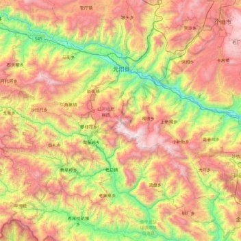
Nombre: Mapa topográfico Yuanyang County, altitud, relieve.
Lugar: Yuanyang County, Honghe, Yunnan, China (22.82863 102.45112 23.31371 103.21836)
Altitud media: 1.358 m
Altitud mínima: 172 m
Altitud máxima: 2.904 m
Haz una donación
Otros mapas topográficos
Haga clic en un mapa para ver su topografía, su altitud y su relieve.
Shangri-La
China > Yunnan > Shangri-La > Jiantang
Shangri-La has either a dry-winter, warm-summer humid continental climate (Köppen climate classification: Dwb), or a dry-winter subtropical highland climate (Köppen climate classification: Cwb), both of which are unusually cool by Yunnan standards due to the high elevation, which ranges between 2,700 and…
Altitud media: 3.674 m
Pingbian
China > Yunnan > Pingbian Miao Autonomous County
Pingbian County has a mild subtropical highland climate (Köppen Cwb) influenced by its elevation, with short, mild, dry winters and warm, humid summers. The monthly 24-hour average temperature ranges from 9.2 °C (48.6 °F) in January to 21.3 °C (70.3 °F) in July, and the annual mean is 16.3 °C (61.3 °F).…
Altitud media: 1.167 m
Haz una donación
Haz una donación
Tengchong
Situated at the southwestern end of the (transversely faulted) Hengduan Mountains, Tengchong topographically assumes the form of a horseshoe with the opening facing the south. The easternmost sources of the Irrawaddy River issue from the high mountains at the summit of Mount Danaozi of Gaoligong Mountain,…
Altitud media: 1.770 m
Haz una donación
Haz una donación