
Haz una donación
Mapa topográfico Tekmen
Haga clic en el mapa para ver la altitud.
Haz una donación
Acerca de este mapa
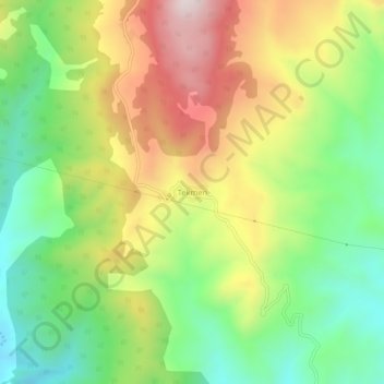
Nombre: Mapa topográfico Tekmen, altitud, relieve.
Lugar: Tekmen, Çorum, Black Sea Region, Turkey (41.00798 34.86463 41.04798 34.90463)
Altitud media: 836 m
Altitud mínima: 566 m
Altitud máxima: 1.192 m
Haz una donación
Otros mapas topográficos
Haga clic en un mapa para ver su topografía, su altitud y su relieve.
Haz una donación
Asia Minor
Anatolia (Turkish: Anadolu), also known as Asia Minor, is a peninsula in West Asia that makes up the majority of the land area of Turkey. It is the westernmost protrusion of Asia and is geographically bounded by the Mediterranean Sea to the south, the Aegean Sea to the west, the Turkish Straits to the…
Altitud media: 399 m
Black Sea Region
The Black Sea region has a steep, rocky coast with rivers that cascade through the gorges of the coastal ranges. A few larger rivers, those cutting back through the Pontic Mountains (Doğu Karadeniz Dağları), have tributaries that flow in broad, elevated basins. Access inland from the coast is limited to a…
Altitud media: 817 m
Haz una donación
Haz una donación
Haz una donación
Haz una donación
Bayat Mahallesi
Çorum (Turkish pronunciation: [ˈtʃoɾum]) (Medieval Greek: Ευχάνεια, romanized: Euchaneia) is a northern Anatolian city in Turkey. Çorum is located inland in the central Black Sea Region of Turkey and is approximately 244 km (152 mi) from Ankara and 608 km (378 mi) from Istanbul. It is the seat of…
Altitud media: 824 m
Haz una donación
Elâzığ
Elazığ (Turkish pronunciation: [eˈlazɯː]) is a city in the Eastern Anatolia region of Turkey, and the administrative centre of Elazığ Province and Elazığ District. Founded in and around the former city of Harput, it is located in the uppermost Euphrates valley. The plain on which the city extends has…
Altitud media: 1.205 m
Haz una donación
Ortaköy
Ortaköy is a town in Aksaray Province in the Central Anatolia region of Turkey, located north of the city of Aksaray. It is the seat of Ortaköy District. Its population is 20,511 (2021). Its average elevation is 1,140 m (3,740 ft). The town consists of 12 quarters, including Balcı.
Altitud media: 1.159 m
Haz una donación
Haz una donación
Haz una donación
Haz una donación
Haz una donación
Haz una donación
Haz una donación
Haz una donación
Haz una donación
Haz una donación
Haz una donación
Haz una donación
Suluova
Suluova is a town in Amasya Province of Turkey, located on high ground inland within the central Black Sea region. It is the seat of Suluova District. Its population is 39,286 (2021). Altitude is 510 m. The mayor is Fatih Üçok (AKP). Two-thirds of the district lies on the plain (watered by the Tersakan…
Altitud media: 716 m
Haz una donación
Haz una donación
Haz una donación
Haz una donación
Haz una donación
Haz una donación