
Gracias por apoyar a este sitio ❤️
Haz una donación
Haz una donación
Mapa topográfico Wandoor
Haga clic en el mapa para ver la altitud.
Gracias por apoyar a este sitio ❤️
Haz una donación
Haz una donación
Wandoor
Wandoor is located in the central area of Malappuram District. The State Highway 73 passes through the town. Its average elevation is 48 metres above the sea level.
Gracias por apoyar a este sitio ❤️
Haz una donación
Haz una donación
Acerca de este mapa
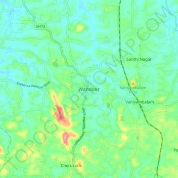
Nombre: Mapa topográfico Wandoor, altitud, relieve.
Lugar: Wandoor, Nilambur, Malappuram, Kerala, 679328, India (11.15574 76.19688 11.23574 76.27688)
Altitud media: 48 m
Altitud mínima: 18 m
Altitud máxima: 138 m
Gracias por apoyar a este sitio ❤️
Haz una donación
Haz una donación
Otros mapas topográficos
Haga clic en un mapa para ver su topografía, su altitud y su relieve.