
Haz una donación
Mapa topográfico Dallas
Haga clic en el mapa para ver la altitud.
Haz una donación
Dallas
Dallas and its surrounding area are mostly flat. The city lies at elevations ranging from 450 to 550 feet (137 to 168 m) above sea level. The western edge of the Austin Chalk Formation, a limestone escarpment (also known as the "White Rock Escarpment"), rises 230 feet (70 m) and runs roughly north–south through Dallas County. South of the Trinity River, the uplift is particularly noticeable in the neighborhoods of Oak Cliff and the adjacent cities of Cockrell Hill, Cedar Hill, Grand Prairie, and Irving. Marked variations in terrain are also found in cities immediately to the west in Tarrant County surrounding Fort Worth, as well as along Turtle Creek north of Downtown.
Haz una donación
Acerca de este mapa
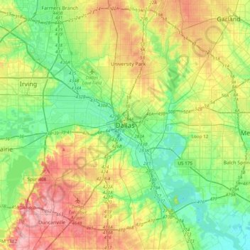
Nombre: Mapa topográfico Dallas, altitud, relieve.
Lugar: Dallas, Dallas County, Texas, United States (32.61627 -96.95686 32.93627 -96.63686)
Altitud media: 158 m
Altitud mínima: 110 m
Altitud máxima: 238 m
Haz una donación
Otros mapas topográficos
Haga clic en un mapa para ver su topografía, su altitud y su relieve.
Deep Ellum PID
United States > Texas > Dallas County > Dallas
Following World War II, the success of Deep Ellum started to fade. The ever-growing availability and use of the automobile led to the removal of the Houston and Texas Central railroad tracks—to make way for Central Expressway—and by 1956 the streetcar line had been removed. Businesses closed, residents…
Altitud media: 145 m
Haz una donación
Haz una donación
Haz una donación