
Haz una donación
Mapa topográfico Whistler Mountain
Haga clic en el mapa para ver la altitud.
Haz una donación
Whistler Mountain
There is a weather station near the summit of Whistler Mountain at the Roundhouse Lodge, located at an elevation of 1835 m (6020 ft). Whistler Roundhouse has a dry-summer subalpine climate (Köppen Dsc), bordering on an Alpine climate (Köppen ET).
Haz una donación
Acerca de este mapa
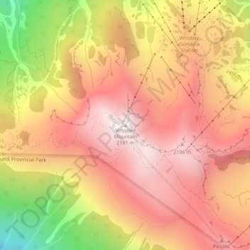
Nombre: Mapa topográfico Whistler Mountain, altitud, relieve.
Altitud media: 1.810 m
Altitud mínima: 1.174 m
Altitud máxima: 2.180 m
Haz una donación
Otros mapas topográficos
Haga clic en un mapa para ver su topografía, su altitud y su relieve.
Alta Lake
Canada > British Columbia > Squamish-Lillooet Regional District > Whistler > Whistler Village
Originally named Summit Lake, Alta Lake was renamed to avoid confusion with the many other Summit Lakes in British Columbia. The name is derived from the Spanish for "high up" or "upper". The lake's southern end is the divide between the basins of the Green and Cheakamus Rivers. The lake is 642 metres (2,106…
Altitud media: 726 m