
Mapa topográfico Alchori
Haga clic en el mapa para ver la altitud.
Acerca de este mapa
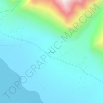
Nombre: Mapa topográfico Alchori, altitud, relieve.
Altitud media: 2.466 m
Altitud mínima: 2.236 m
Altitud máxima: 3.548 m
Otros mapas topográficos
Haga clic en un mapa para ver su topografía, su altitud y su relieve.
Biafo Glacier
Pakistan > Gilgit-Baltistan > Shigar District
Biafo Glacier converging at Hispar La with 49 kilometres (30 mi) long Hispar Glacier situated at an elevation of 5,128 metres (16,824 ft), forms the glacial system considered as the world's longest non-polar glacial system which spans an overall distance of around 120 kilometres (75 mi). This frozen pathway…
Altitud media: 4.618 m