
Haz una donación
Mapa topográfico Yabēlo
Haga clic en el mapa para ver la altitud.
Haz una donación
Yabēlo
Yabelo (Oromo: Yaabeelloo) is a town in southern Ethiopia. An alternative name for this town is Obda, which is also the name of a nearby mountain. Located northwest of Moyale in the Borena Zone of the Oromia, this town has a latitude and longitude of 4°53′N 38°5′E / 4.883°N 38.083°E / 4.883; 38.083 and an elevation of 1857 meters above sea level. It has been the administrative center of the Borena Zone since its division from Guji Zone in September 2002, as well as Yabelo woreda.
Haz una donación
Acerca de este mapa
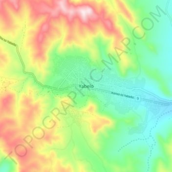
Nombre: Mapa topográfico Yabēlo, altitud, relieve.
Lugar: Yabēlo, Borena, Oromia Region, Ethiopia (4.85257 38.05499 4.93257 38.13499)
Altitud media: 1.853 m
Altitud mínima: 1.627 m
Altitud máxima: 2.200 m
Haz una donación
Otros mapas topográficos
Haga clic en un mapa para ver su topografía, su altitud y su relieve.
Bale Mountains National Park
The Bale Mountains play a vital role in climate control of the region by attracting large amounts of orographic rainfall, which has obvious implications for livestock and agricultural production. Some 600–1,000 mm (24–39 in) fall annually in the lower altitude areas, while 1,000–1,400 mm (39–55 in)…
Altitud media: 2.612 m
Haz una donación
Lake Langano
Lake Langano (Oromo: Hora Langaanoo, Amharic: ላንጋኖ ሐይቅ) is a lake in the Oromia Region of Ethiopia, exactly 200 kilometers by road south of the capital, Addis Ababa, on the border between the East Shewa Zone and Arsi Zones. It is located to the east of Lake Abijatta in the Main Ethiopian Rift at…
Altitud media: 1.625 m
Haz una donación