
Mapa topográfico 1st District of Patras - Arctic Sector
Mapa interactivo
Haga clic en el mapa para ver la altitud.
Acerca de este mapa
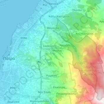
Nombre: Mapa topográfico 1st District of Patras - Arctic Sector, altitud, relieve.
Altitud media: 375 m
Altitud mínima: -3 m
Altitud máxima: 1.840 m
Otros mapas topográficos
Haga clic en un mapa para ver su topografía, su altitud y su relieve.
Kato Lousi
Greece > Peloponnese, Western Greece and the Ionian > Achaea Regional Unit > Municipality of Kalavryta
Kato Lousi, Municipality of Kalavryta, Achaea Regional Unit, Western Greece, Peloponnese, Western Greece and the Ionian, 250 01, Greece
Altitud media: 1.172 m
Municipality of Kalavryta
Greece > Peloponnese, Western Greece and the Ionian > Achaea Regional Unit
Municipality of Kalavryta, Achaea Regional Unit, Western Greece, Peloponnese, Western Greece and the Ionian, Greece
Altitud media: 975 m
Municipal Unit of Movri
Greece > Peloponnese, Western Greece and the Ionian > Achaea Regional Unit
Municipal Unit of Movri, Municipality of West Achaea, Achaea Regional Unit, Western Greece, Peloponnese, Western Greece and the Ionian, 250 05, Greece
Altitud media: 55 m
Patras
Greece > Peloponnese, Western Greece and the Ionian > Achaea Regional Unit > Patras
Patras, Municipal Unit of Patras, Municipality of Patras, Achaea Regional Unit, Western Greece, Peloponnese, Western Greece and the Ionian, 26221, Greece
Altitud media: 283 m