
Haz una donación
Mapa topográfico Malolos
Haga clic en el mapa para ver la altitud.
Haz una donación
Malolos
Malolos is relatively flat of about 0.81% to a gently sloping of 2.17%. The slope of the land descends towards west, southwest to southern direction. The highest land elevation is at about 6.0 meters above sea level while the lowest is only half a meter below sea level. A network of natural waterways and rivers of various sizes and importance is traversing through the landscape of the town down south to Manila Bay.
Haz una donación
Acerca de este mapa
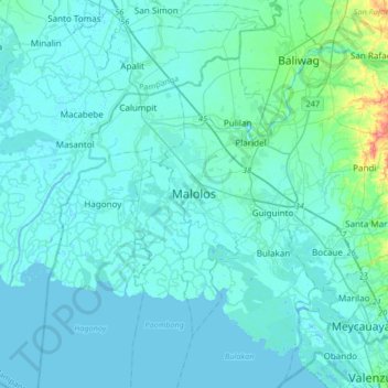
Nombre: Mapa topográfico Malolos, altitud, relieve.
Lugar: Malolos, Bulacan, Central Luzon, 3000, Philippines (14.68376 120.65137 15.00376 120.97137)
Altitud media: 6 m
Altitud mínima: -3 m
Altitud máxima: 74 m
Haz una donación
Otros mapas topográficos
Haga clic en un mapa para ver su topografía, su altitud y su relieve.
Pulilan
The municipality is generally of flat topography. Eleven (11) of its barangays are bounded by the Angat River. The rest are flat irrigated rice lands. Soil types vary from sandy loam to clay loam which makes the municipality suitable to a wide range of agricultural products.
Altitud media: 10 m
Haz una donación
Obando
Flat and low-lying coastal plains characterize the general topography of Obando. The area was formerly an estuary, but it filled up partially from the peripheral parts of each sand bar and sand spit and formed up into current figure that mainly consisted of commercial district, partly industrial district,…
Altitud media: 4 m