
Mapa topográfico Kencana
Haga clic en el mapa para ver la altitud.
Acerca de este mapa
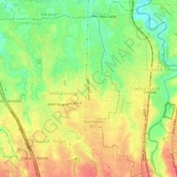
Nombre: Mapa topográfico Kencana, altitud, relieve.
Lugar: Kencana, Bogor, West Java, Java, 16167, Indonesia (-6.55099 106.76671 -6.51099 106.80671)
Altitud media: 164 m
Altitud mínima: 131 m
Altitud máxima: 191 m
Otros mapas topográficos
Haga clic en un mapa para ver su topografía, su altitud y su relieve.
Cisarua
The district is known for its mild climate, tea fields, and extensive views, being located at a rather high altitude. Near the district is a mountain pass known for its villas and hostels, as well as a well-known "heritage" hotel known as the "Puncak Pass", built in 1928.
Altitud media: 1.270 m
Ciliwung
Mean rainfall reaches 3,125 mm, with a mean annual discharge of 16 m3/s as measured at Ciliwung Ratujaya observation station (231 km2). With such topographical, geological, and hydrological features, the Ciliwung River is often overflowing and inundating parts of Jakarta. The population along the Ciliwung…
Altitud media: 328 m
Ciliwung
Mean rainfall reaches 3,125 mm, with a mean annual discharge of 16 m3/s as measured at Ciliwung Ratujaya observation station (231 km2). With such topographical, geological, and hydrological features, the Ciliwung River is often overflowing and inundating parts of Jakarta. The population along the Ciliwung…
Altitud media: 229 m
Jonggol
Jonggol is a district (Indonesian: Kecamatan) in the Bogor Regency, West Java, Indonesia. It is located 50 km to the southeast of Jakarta and is part of the Greater Jakarta metropolitan area. The average elevation is 295 meters, maximum 732 m (1.890 m in Mounth Baud, Sukamakmur, Jonggol District), and minimum…
Altitud media: 237 m
Ciliwung
Mean rainfall reaches 3,125 mm, with a mean annual discharge of 16 m3/s as measured at Ciliwung Ratujaya observation station (231 km2). With such topographical, geological, and hydrological features, the Ciliwung River is often overflowing and inundating parts of Jakarta. The population along the Ciliwung…
Altitud media: 328 m