
Haz una donación
Mapa topográfico North District
Haga clic en el mapa para ver la altitud.
Haz una donación
Acerca de este mapa
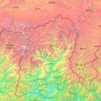
Nombre: Mapa topográfico North District, altitud, relieve.
Lugar: North District, Mangan, Sikkim, India (26.96667 87.80000 28.36667 89.20000)
Altitud media: 3.760 m
Altitud mínima: 258 m
Altitud máxima: 8.489 m
Haz una donación
Otros mapas topográficos
Haga clic en un mapa para ver su topografía, su altitud y su relieve.
Mangan
Mangan is the largest of the six districts of Sikkim. The landscape is mountainous with dense vegetation all the way up to the alpine altitude before thinning out to desert scrub towards the northern tundra. Numerous waterfalls astride the main road make the trip to this district extremely picturesque.
Altitud media: 4.407 m
Haz una donación
West Sikkim District
West Sikkim (now officially named as Geyzing District) is a district of the Indian state of Sikkim. Its headquarter is Geyzing, also known as Gyalshing. The district is a favourite with trekkers due to the high elevations. Other important towns include Pelling and Yuksom. Local people also call it as…
Altitud media: 2.686 m
Haz una donación
Haz una donación
Haz una donación
Haz una donación
Haz una donación
Mangan
Mangan is the largest of the six districts of Sikkim. The landscape is mountainous with dense vegetation all the way up to the alpine altitude before thinning out to desert scrub towards the northern tundra. Numerous waterfalls astride the main road make the trip to this district extremely picturesque.
Altitud media: 4.407 m