
Haz una donación
Mapa topográfico Antony
Haga clic en el mapa para ver la altitud.
Haz una donación
Antony
Antony is a city in the southern suburbs of Paris in the Hurepoix and is the chief town of the arrondissement of Hauts-de-Seine - 12.2 km south of Notre-Dame Cathedral. Its altitude is 48m above sea level at the lowest point at rue Gabriel Chamon in the Bièvre Valley and 100m at the highest point in the Avenue d'Estienne d'Orves on the border with Châtenay-Malabry. Antony is at the intersection of three departments.
Haz una donación
Acerca de este mapa
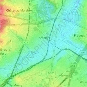
Nombre: Mapa topográfico Antony, altitud, relieve.
Altitud media: 76 m
Altitud mínima: 46 m
Altitud máxima: 150 m
Haz una donación
Otros mapas topográficos
Haga clic en un mapa para ver su topografía, su altitud y su relieve.
Haz una donación
Parc de Billancourt
France > Ile-de-France > Hauts-de-Seine > Boulogne-Billancourt
Altitud media: 58 m
Val Saint-Olaf
France > Ile-de-France > Hauts-de-Seine > Chaville > Val Saint-Olaf
Altitud media: 128 m