
Mapa topográfico Bahawalnagar
Haga clic en el mapa para ver la altitud.
Bahawalnagar
In 1904 when Nawab Mohammad Bahawal Khan Abbasi IV, who originally ruled over Bahawalpur State visited Rojhanwali the people asked that with His permission they want to rename the city on the name of Nawab, The Nawab allowed them with pleasure and since then the city is named as Bahawalnagar. With the advent of railways, 40–50 shops with a population of 100 dwelling units developed at existing railway bazar. Though this site was not fit for flourishing as the topographical features were not favorable and drinking water was unfit for health. With the introduction of canal system, it has become fertile area. The real achievement was Fordwah Canal which brought almost the entire district under the command of irrigation system. The town developed as colony town south of railway station.
Acerca de este mapa
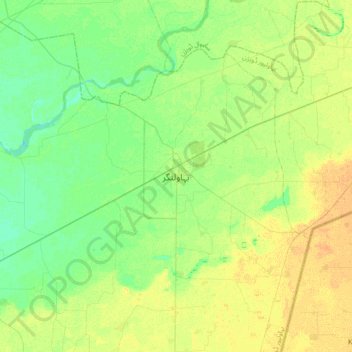
Nombre: Mapa topográfico Bahawalnagar, altitud, relieve.
Altitud media: 158 m
Altitud mínima: 148 m
Altitud máxima: 170 m
Otros mapas topográficos
Haga clic en un mapa para ver su topografía, su altitud y su relieve.
Faisalabad City Tehsil
The soil consists of young stratified silt loam or very fine sand loam which makes the subsoil weak in structure with common kankers at only five feet. The course of the rivers within Faisalabad is winding and often subject to frequent alternations. In the rainy season, the currents are very strong. This leads…
Altitud media: 185 m
Pakpattan District
Malka Hans is the ancient famous town near Pakpattan in Pakpattan District located between Pakpattan and Sahiwal on Sahiwal Road. Malka Hans is located at 30°25′26.4″N 73°16′33.6″E / 30.424000°N 73.276000°E / 30.424000; 73.276000 at an altitude of 150 metres (490 ft).
Altitud media: 162 m
Ravi River
The Ravi River originates in the Himalayas in the Multhan tehsil of Kangra district of Himachal Pradesh, India. It follows a north-westerly course and is a perennial river. It is the smallest of the five Punjab rivers that rise from glacier fields at an elevation of 14,000 feet (4,300 m), on the southern side…
Altitud media: 171 m
Faisalabad City Tehsil
The soil consists of young stratified silt loam or very fine sand loam which makes the subsoil weak in structure with common kankers at only five feet. The course of the rivers within Faisalabad is winding and often subject to frequent alternations. In the rainy season, the currents are very strong. This leads…
Altitud media: 185 m
Gujranwala City Tehsil
Gujranwala sits at the heart of the Rechna Doab, a strip of land between the Chenab in the north, and Ravi River in the south. Gujranwala is also part of the Majha, a historical region of northern Punjab. The city was built upon the plains of Punjab, and the surrounding region is an unbroken plain devoid of…
Altitud media: 225 m
Lalamusa
Pakistan > Punjab > Gujrat District
Lalamusa is situated on the Grand Trunk Road (National Highway 5). It is geographically located at latitude (32.7 degrees) 32° 42' 0" North of the Equator and longitude (73.96 degrees) 73° 57' 35" East of the Prime Meridian on the Map of the world and lies at an altitude of about 250 meters.
Altitud media: 254 m
Faisalabad City Tehsil
The soil consists of young stratified silt loam or very fine sand loam which makes the subsoil weak in structure with common kankers at only five feet. The course of the rivers within Faisalabad is winding and often subject to frequent alternations. In the rainy season, the currents are very strong. This leads…
Altitud media: 185 m