
Haz una donación
Mapa topográfico Bethel Park
Haga clic en el mapa para ver la altitud.
Haz una donación
Bethel Park
According to the U.S. Census Bureau, the borough had a total area of 11.7 square miles (30 km2), all of it land. Its average elevation is 1,197 feet (365 m) above sea level. Bethel Park lies at the margin between the Pittsburgh Low Plateau and Waynesburg Hills Sections of the Allegheny Plateau physiographic province. The area is characterized as a maturely dissected region where the ephemeral minor tributaries converge into the tributaries of principal streams.
Haz una donación
Acerca de este mapa
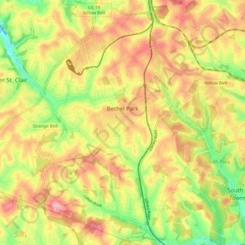
Nombre: Mapa topográfico Bethel Park, altitud, relieve.
Altitud media: 347 m
Altitud mínima: 266 m
Altitud máxima: 416 m
Haz una donación
Otros mapas topográficos
Haga clic en un mapa para ver su topografía, su altitud y su relieve.
Haz una donación
Champion
United States > Pennsylvania > Allegheny County > North Fayette Township
Altitud media: 360 m
Haz una donación
Coraopolis Heights
United States > Pennsylvania > Allegheny County > Findlay Township
Altitud media: 320 m
Haz una donación
Central Highlands
United States > Pennsylvania > Allegheny County > Elizabeth Township
Altitud media: 327 m
Sturgeon
United States > Pennsylvania > Allegheny County > North Fayette Township
Altitud media: 334 m
Haz una donación
Haz una donación
Highland Park Reservoir No. 2
United States > Pennsylvania > Allegheny County > Pittsburgh
Altitud media: 275 m
Allegheny River Lock and Dam No. 2
United States > Pennsylvania > Allegheny County > O'Hara Township
Altitud media: 268 m
Haz una donación
Haz una donación
Haz una donación
Neville Island
United States > Pennsylvania > Allegheny County > Neville Township
Altitud media: 289 m
Coverdale
United States > Pennsylvania > Allegheny County > Bethel Park > Coverdale
Altitud media: 354 m
Haz una donación
Clinton
United States > Pennsylvania > Allegheny County > Findlay Township > Clinton
Altitud media: 350 m
Glenwillard
United States > Pennsylvania > Allegheny County > Crescent Township > Glenwillard
Altitud media: 278 m
Haz una donación