
Mapa topográfico Neukölln
Mapa interactivo
Haga clic en el mapa para ver la altitud.
Acerca de este mapa
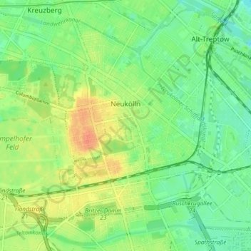
Nombre: Mapa topográfico Neukölln, altitud, relieve.
Lugar: Neukölln, Berlin, Germany (52.45876 13.40608 52.49587 13.47855)
Altitud media: 43 m
Altitud mínima: 26 m
Altitud máxima: 67 m
Neukölln lies on the geological border between the shallow Berliner Urstromtal glacial valley and the Tempelhofer Berge, which are situated in the northernmost region of the Teltow ground moraine plateau, rising to the south of Hermannplatz, in what is mostly the typical low-lying marshy woodlands with a mainly flat topography of the North European Plain.
Otros mapas topográficos
Haga clic en un mapa para ver su topografía, su altitud y su relieve.
Friedrichshain-Kreuzberg
Friedrichshain-Kreuzberg, Berlin, Germany
Altitud media: 45 m
Charlottenburg-Wilmersdorf
Charlottenburg-Wilmersdorf, Berlin, Germany
Altitud media: 44 m
Volkspark Friedrichshain
Volkspark Friedrichshain, Barnimkiez, Friedrichshain, Friedrichshain-Kreuzberg, Berlin, 10249, Germany
Altitud media: 49 m
Charlottenburg
Charlottenburg, Charlottenburg-Wilmersdorf, Berlin, Germany
Altitud media: 41 m
Biesenhorster Sand
Biesenhorster Sand, Tangentiale Verbindung Ost, , Biesdorf, Marzahn-Hellersdorf, Berlin, 12683, Germany
Altitud media: 38 m
Volkspark am Weinberg
Volkspark am Weinberg, Spandauer Vorstadt, Mitte, Berlin, 10119, Germany
Altitud media: 47 m