
Haz una donación
Mapa topográfico Vérignon
Haga clic en el mapa para ver la altitud.
Haz una donación
Vérignon
The plain is also an important findspot for prehistoric fossils, with most of those found being conserved fossils in the château at Vérignon, not open to the public. According to Raoul Bérenguier, the Blacas seigneurs of Aups installed themselves in Vérignon around the year 1000 and constructed their castle on a rocky outcrop in the town. It had an encircling wall, rectangular living quarters in the north corner, a private chapel of the Assumption for the Blacas (with their family vault under its altar), and a barbican round its south gate. However, this castle proved too constricted, uncomfortable and small, and was abandoned at the start of the 18th century, with the Blacas building a new, unfortified château, which remained in their hands until 1947. It is rectangular in plan, with two levels of overhanging elevations, an attic-storey, and corner towers. Two short wings project out from and frame the main building. The castle stands up in the middle of a magnificent park.
Haz una donación
Acerca de este mapa
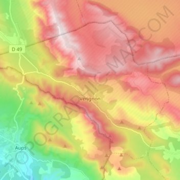
Nombre: Mapa topográfico Vérignon, altitud, relieve.
Altitud media: 824 m
Altitud mínima: 452 m
Altitud máxima: 1.143 m
Haz una donación
Otros mapas topográficos
Haga clic en un mapa para ver su topografía, su altitud y su relieve.
Haz una donación
Puget-sur-Argens
France > Provence-Alpes-Côte d'Azur > Var > Puget-sur-Argens > Puget-sur-Argens
Altitud media: 20 m
Grotte des Tuves
France > Provence-Alpes-Côte d'Azur > Var > Saint-Cézaire-sur-Siagne
Altitud media: 362 m
La Seyne-sur-Mer
France > Provence-Alpes-Côte d'Azur > Var > La Seyne-sur-Mer > La Seyne-sur-Mer
Altitud media: 35 m
Haz una donación
Haz una donación
Embut de la Plaine des Enfers
France > Provence-Alpes-Côte d'Azur > Var > Cuges-les-Pins
Altitud media: 564 m
Haz una donación
Haz una donación