
Haz una donación
Mapa topográfico Yoho National Park
Haga clic en el mapa para ver la altitud.
Haz una donación
Yoho National Park
The weather in the park is localized and changeable. Located on the western side of the continental divide, it receives more precipitation than areas east of the divide. Precipitation in the park increases with elevation. In winter, average temperatures are between 5 and −15 °C (41.0 and 5.0 °F) from the months November to April although temperatures can range between 10 and −35 °C (50.0 and −31.0 °F). The coldest weather usually occurs in the months December to February. In summer, mean temperatures average 12.5 °C (54.5 °F) with an average high of 20 °C (68.0 °F) and an average low of 5 °C (41.0 °F). Snowfall and freezing temperatures can occur during the summertime at altitudes above 1,500 m (4,900 ft).
Haz una donación
Acerca de este mapa
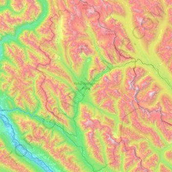
Nombre: Mapa topográfico Yoho National Park, altitud, relieve.
Altitud media: 1.934 m
Altitud mínima: 779 m
Altitud máxima: 3.472 m
Haz una donación
Otros mapas topográficos
Haga clic en un mapa para ver su topografía, su altitud y su relieve.
Mount Macdonald
Canada > British Columbia > Columbia-Shuswap Regional District > Area A (Kicking Horse/Kinbasket Lake)
Altitud media: 2.019 m
Mount Murray
Canada > British Columbia > Columbia-Shuswap Regional District > Area B (Shelter Bay/Mica Creek)
Altitud media: 1.971 m
McMurdo
Canada > British Columbia > Columbia-Shuswap Regional District > Area A (Kicking Horse/Kinbasket Lake)
Altitud media: 852 m
Mount Selwyn
Canada > British Columbia > Columbia-Shuswap Regional District > Area A (Kicking Horse/Kinbasket Lake)
Altitud media: 2.626 m
Haz una donación
Mount Cairnes
Canada > British Columbia > Columbia-Shuswap Regional District > Area A (Kicking Horse/Kinbasket Lake)
Altitud media: 2.493 m
Boyd Creek
Canada > British Columbia > Columbia-Shuswap Regional District > Area B (Shelter Bay/Mica Creek)
Altitud media: 1.570 m