
Gracias por apoyar a este sitio ❤️
Haz una donación
Haz una donación
Mapa topográfico Bally
Haga clic en el mapa para ver la altitud.
Gracias por apoyar a este sitio ❤️
Haz una donación
Haz una donación
Bally
Bally is located at 22°39′N 88°20′E / 22.65°N 88.34°E / 22.65; 88.34 and also the northernmost part of Howrah city. It has an average elevation of 15 metres (49 feet). It is more elevated in the west than the east (where flows the Hoogly river), thus leading to a problem of water logging. Bally is separated from Uttarpara, Hooghly by Bally Canal (Bally Khal) at its north. A Bridge was constructed over Bally Canal in 1846 to join the two localities.
Gracias por apoyar a este sitio ❤️
Haz una donación
Haz una donación
Acerca de este mapa
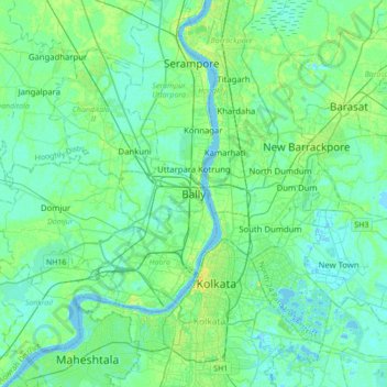
Nombre: Mapa topográfico Bally, altitud, relieve.
Lugar: Bally, Bally Jagachha, Howrah, West Bengal, 712258, India (22.48696 88.18361 22.80696 88.50361)
Altitud media: 6 m
Altitud mínima: -3 m
Altitud máxima: 23 m
Gracias por apoyar a este sitio ❤️
Haz una donación
Haz una donación