
Haz una donación
Mapa topográfico Mount Narodnaya
Haga clic en el mapa para ver la altitud.
Haz una donación
Mount Narodnaya
Mount Narodnaya (also known as Naroda and Poenurr; Russian: гора Народная, Komi: Народа-Из ("People's Mountain"), Mansi: Поэӈ-ур, Поэн-урр) is the highest peak of the Urals in Russia. Its elevation is 1,894 metres (6,214 ft). It is located on the border between Khanty–Mansi Autonomous Okrug in Tyumen Oblast and Komi Republic, the highest point being 0.5 km to the east from the border. The name may refer to Naroda River, which originates from the mount, located in the Research Range.
Haz una donación
Acerca de este mapa
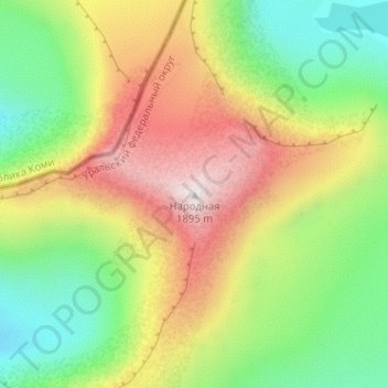
Nombre: Mapa topográfico Mount Narodnaya, altitud, relieve.
Altitud media: 1.437 m
Altitud mínima: 1.096 m
Altitud máxima: 1.893 m
Haz una donación
Otros mapas topográficos
Haga clic en un mapa para ver su topografía, su altitud y su relieve.
Шайтанка
Russia > Khanty-Mansiysk Autonomous Okrug – Ugra > Beryozovsky District > Beryozovo
Altitud media: 24 m
Хурумпауль
Russia > Khanty-Mansiysk Autonomous Okrug – Ugra > Beryozovsky District
Altitud media: 21 m